Extreme winter weather will blanket the eastern half of the U.S. this weekend with a combination of bitterly cold temperatures, gusty wind and — for some — heavy snow.
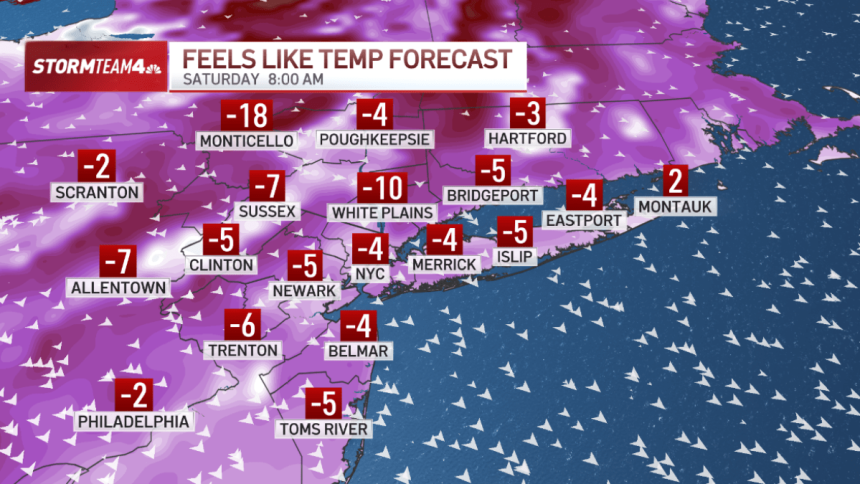
For the tri-state, cold weather advisories are in place through at least Saturday morning. Wind chill temperatures Saturday morning will drop below zero, well into the danger zone.


The advisory will likely be extended by the National Weather Service through Sunday, as wind chills on the back half of the weekend will be just as brutal.
Afternoon temperatures will only peak in the low 20s, but daytime wind chills will only be in the single digits. Sunday, especially, will be brisk. Wind gusts will be between 30 and 40 miles per hour as a storm passes offshore.

That coastal storm will pull the Arctic air well into Florida. Central Florida will drop below freezing Sunday morning. Miami will wake up to temperatures in the 30s!
Snow totals in the Mid-Atlantic will be anywhere from five inches to a foot, with eastern North Carolina getting hit the hardest. Here in the tri-state, the storm travel too far offshore for it to impact us with anything more than gusty wind. Cape Cod may get clipped by moderate snow, but eastern Long Island is in for closer to a dusting.


The worst of the cold air will be over by Monday, when temperatures moderate…somewhat. We’ll still be cold for this time of year, but temperatures next week will run nearly 10 degrees warmer than this weekend.