A rapidly intensifying nor’easter is forecast to impact New York City and much of the Northeast from Sunday into Monday, bringing heavy snow, powerful winds, and dangerous blizzard conditions.
Stay with us for live updates on snowfall totals, travel disruptions, power outages, and safety advisories.
State courthouses in Rockland and Westchester counties as well as several counties further north will be closed on Monday.
The shutdown list includes courts in Orange, Putnam, Dutchess, Sullivan, Ulster, Green and Columbia counties as well as the Long Island counties.
Criminal court arraignment sections in New York City’s five boroughs will open at 2 p.m. Monday.
Over 50 New York City hospitals, schools and the city’s Department of Homeless Services will be operating warming centers for those who need to escape the cold, among other locations.
Sites are located in each of the five boroughs.
For a full list of warming centers and schedules, go to Portal.311.nyc.gov.
During a Code Blue, individuals can stay at shelters or drop-in centers without having to go through the traditional intake process.
Paying too much for food, gas, batteries, generators or hotel stays during the storm?
New York Attorney General Letitia James is warning consumers to watch out for price gouging.
“As New Yorkers prepare for another snowstorm, my office is on the lookout for those trying to take advantage of consumers with excessive price hikes,” James said. “I encourage everyone to be vigilant and report examples of price gouging in their community to my office.”
Businesses that provide goods and services essential to health and safety are prohibited from taking advantages of consumers by charging “unconscionably excessive” prices during emergencies, the attorney general said.
As if the snow wasn’t enough.
On Sunday afternoon, The National Weather Service issued a coastal flood warning for waterfront towns in southern Westchester County as well as Connecticut from midnight Sunday through 5 a.m. Monday.
Flooding of 1 ½ to 2 ½ feet above ground is possible in low-lying areas, which could result in road closures.
Much depends on the force of the winds during high tide. Meantime, the weather service recommends taking precautions to protect flood-prone property. And if you’re on the road, don’t drive through barricades or water of unknown depth.
Metro-North Railroad remains on its regular schedule Sunday.
But Monday, as the work week starts, the railroad shifts to an hourly schedule on the Harlem, Hudson and New Haven lines. The branch lines — Wassaic, Danbury, New Canaan, and Waterbury — will be on a weekend schedule.
Bus service is suspended on the Hudson Rail Link over the Gov. Mario M. Cuomo Bridge as well as shuttle bus service between Haverstraw and Ossining that’s been subbing in for ferry service while there’s ice on the Hudson River.
Meanwhile, the Long Island Rail Road will totally shut down at 1 a.m. Monday.
“This proactive suspension allows crews to focus on snow-clearing efforts from this extreme winter weather event, which includes projected extreme velocity winds on eastern Long Island, to provide safe and reliable service when possible,” the MTA said Sunday afternoon. Best to check the MTA website and TrainTime apps for an up-to-the-minute schedule.
Empty tractor-trailers and tandem trucks are banned on the MTA’s seven bridges between 7 p.m. Sunday and 10 a.m. Monday.
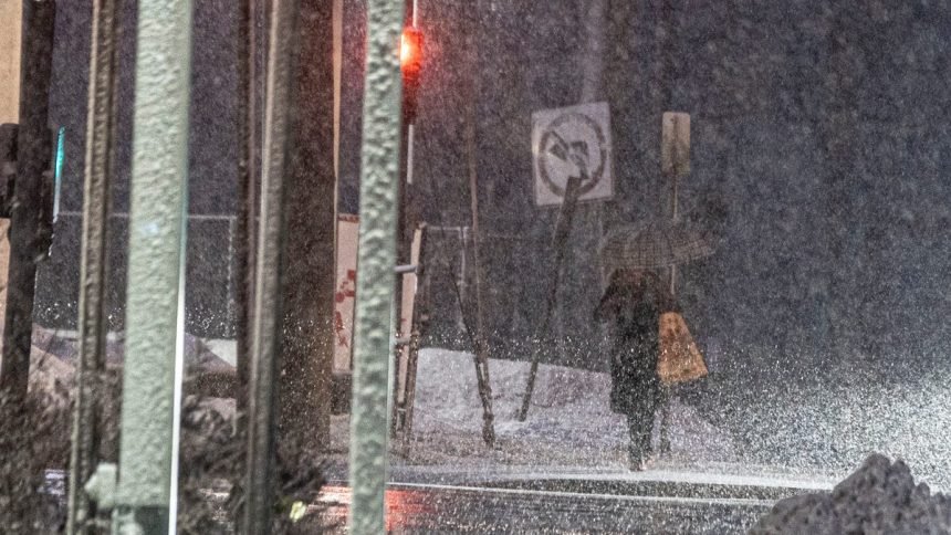
Winter Storm Hernando has begun in New York, with flurries and slow-moving flakes observed in Westchester, Rockland, Putnam and New York City as of 12:30 p.m.
Between 10 to 15 inches of snow is expected in the Lower Hudson Valley, with wind gusts between 40 to 45 mph. In New York City, 12 to 18 inches is possible, with wind gusts up to 55 mph in coastal areas. 1 to 2 inches of snow is expected to fall per hour until Monday morning.
New York City Mayor Zohran Mamdani announced the city-wide state of emergency Sunday afternoon during a press conference, saying a mix of heavy snow, possible flooding due to high tides and freezing temperatures is expected to cause highly dangerous road conditions throughout the city and surrounding areas.
Non-essential traffic from cars, trucks, scooters and e-bikes will be banned starting 9 p.m. Sunday evening until noon Monday.
“These are blizzard conditions. New York City has not faced a storm of this scale in the last decade,” Mamdani said during a press conference Sunday afternoon. “Please for your safety, stay home, stay inside and stay off the roads.”
Additionally, all New York City schools will be closed tomorrow for an “old-school snow day.” Mamdani said it’s the first official snow day without remote learning since before COVID in 2019.
Other non-essential government offices and services, such as the New York Public Library, Staten Island Ferry and New York Ferry, will also be closed Monday.
Communities along the Hudson River in Westchester and Rockland counties are preparing for impact as the highly anticipated Sunday evening blizzard approaches.
In Rockland, County Executive Ed Day declared a county-wide state of emergency effective 6 p.m. Sunday, expecting local snow accumulations between 18 and 24 inches. Day advised all vehicles should be off county roads by 6 p.m. through Monday, unless in the case of essential travel.
“This decisive action is necessary to protect lives and ensure our road crews can clear snow as quickly and safely as possible,” said Day. “With blizzard conditions expected, visibility will be extremely limited and travel will become dangerous very quickly. Keeping vehicles off the roads allows plows and emergency responders to operate without obstruction. We are asking every resident to comply so we can get through this storm safely.”
River communities such as Nyack, Port Chester and Yonkers have also declared individual snow emergencies, which designates snow emergency zones on roads along the river. No parked or standing vehicles will be permitted in these areas from 6 p.m. Saturday in Yonkers and 8 a.m. Sunday in Nyack through Monday morning, in order to allow for salt trucks and snowplows through the roads as the storm progresses. Temporary parking will be available for residents in certain municipal lots. For more information, visit the Village of Nyack and City of Yonkers websites.
In Westchester, a county-wide road ban will be implemented starting at 9 p.m. All county roads will be closed to commuter traffic, except for essential travel such as police, fire department or emergency services activity.
“Residents should stay off the roads during this time to allow emergency crews and road treatment teams to operate safely and effectively,” Westchester County said in a press release Sunday. “Travel conditions are expected to be treacherous to impossible, particularly during the overnight hours.”
Warming centers throughout Westchester and Rockland are expected to be open in case of localized power outages. To find warming centers in Westchester, visit the Westchester County official website. To find warming centers in Rockland, visit the Rockland County official website.
Orange & Rockland, ConEdison and NYSEG have mobilized emergency crews to remain on standby in case of power outages and other emergencies anticipated during Sunday’s blizzard.
Orange & Rockland said Orange and Rockland counties may experience winds between 25 and 50 mph as over a foot of snow falls. The conditions could cause downed power lines, tree limbs and utility poles, as well as widespread outages. The utility service said 50 mutual aid workers are on hand to assist with emergency repairs.
In Putnam, Dutchess and other parts of the Hudson Valley, NYSEG has mobilized 40 additional tree-cutting and emergency line crews to its staff to mitigate outages caused by expected heavy, wet snow and winds between 40 and 45 mph.
You can check out utility company outage maps by clicking on the links below.
To report an outage:
Gov. Kathy Hochul on Saturday declared a State of Emergency in more than 20 counties and activated the New York National Guard ahead of a powerful blizzard expected to impact New York City, Long Island and the Hudson Valley.
Officials warn the storm could bring dangerous travel conditions, coastal flooding and widespread power outages.
Beginning Sunday, 100 National Guard members and 25 vehicles will be staged across downstate regions to assist with storm response. The State Emergency Operations Center will also activate Sunday morning. Winter Storm Warnings are in effect for parts of the Hudson Valley, where 10 to 15 inches of snow and wind gusts up to 45 mph are possible. Additional counties are under Winter Storm Watches.
Transit agencies are adjusting service, and beginning at 4 p.m. Sunday, empty commercial vehicles and tandem tractor trailers will be banned from I-84 and roads south of it, including sections of the Thruway. Hochul urged residents to prepare now, avoid unnecessary travel and monitor weather updates.
Forecasters say the storm will strengthen quickly offshore, producing snowfall rates of 1–2 inches per hour and wind gusts of 50 to 55 mph. AccuWeather warns that heavy snow combined with strong winds could create blizzard conditions across Long Island, New York City, and coastal areas.
“The storm will be incredibly disruptive and dangerous,” said Carl Erickson, AccuWeather director of forecasting operations. “Blowing snow and near-zero visibility will make travel nearly impossible during the worst of the storm.”
The strongest winds are expected Sunday night into early Monday.
The National Weather Service has issued:
Blizzard Warning (6 a.m. Sunday to 6 p.m. Monday):
- New York City (Manhattan, Bronx, Brooklyn, Queens, Staten Island)
- Southern Westchester
- Southern Nassau
- Southeast Suffolk
Expected impacts:
- 13–18 inches of snow
- Wind gusts up to 55 mph
- Whiteout conditions
- Dangerous travel
- Possible power outages
Winter Storm Warning (same timeframe):
- Orange County
- Putnam County
- Northern Westchester
Expected impacts:
- 10–15 inches of snow
- Wind gusts up to 45 mph
- Reduced visibility and hazardous roads
- Snow will begin Sunday morning and intensify through the evening.
Projected totals:
12–18 inches: Parts of Long Island and the Cape6–10 inches: New York City8–12 inches: Boston3–6 inches: Baltimore1–3 inches: Washington, D.C.
Localized higher amounts are possible if heavier snow bands develop.
- Highways, rail lines, and airports across the Northeast are expected to face significant delays.
- AccuWeather estimates more than 2,500 flight cancellations Sunday into Monday.
- Blowing and drifting snow could make roads impassable at times. Officials warn drivers could become stranded for hours during peak storm conditions.
- Residents are urged to avoid nonessential travel.
- Strong winds combined with heavy snow could bring scattered power outages, especially in coastal neighborhoods and areas where snow starts wet and heavy.
- Coastal regions from Delmarva through Long Island face:
- High waves
- Beach erosion
- Possible coastal flooding during high tide
If travel is unavoidable:
- Keep a winter survival kit in your vehicle (flashlight, food, water)
- Drive slowly and allow extra stopping distance
- Avoid sudden braking or acceleration
- Check local DOT updates before heading out
- If stranded, remain with your vehicle
Officials say travel during peak blizzard conditions could be life-threatening.
This marks the fifth consecutive weekend of accumulating snow for parts of the Northeast. New York City has recorded 22.3 inches of snow this season, near its historical average of 22.1 inches. Recent bitter cold has already driven higher heating costs and widespread disruptions.