NIGHT AND THEN A QUIET DOWN. I MEAN, WHAT YOU’RE GOING THROUGH FOR DAYS ON END, WE WILL FEEL THE IMPACT OF THAT SAME SYSTEM. IT’S A REALLY STRONG COLD FRONT. SO FOR US, WE’LL FEEL IT IN THE FORM OF RAIN AND IT COULD BE HEAVY AT TIMES. AND WE’LL ALSO FEEL IT IN THE FORM OF A SIGNIFICANT, SIGNIFICANT COOL DOWN, WHICH OF COURSE WILL IMPACT OUR FORECAST FOR MONDAY. SO HERE’S THE SYSTEM RIGHT NOW. YOU CAN SEE THIS LINE THAT STRETCHES WITH RAIN FROM THE GREAT LAKES ALL THE WAY DOWN TO THE SOUTHERN PLAINS. WE HAVE SOME TRAVEL TIME BEFORE IT MOVES TOWARD US, BUT AS A RESULT, YOU HAVE IMPACT WEATHER FOR MOST OF YOUR SUNDAY. THE RAIN MOVING IN IN THE MORNING AND DOESN’T EXIT UNTIL CLOSE TO SUNSET. AS WE’RE TALKING ABOUT MOST OF YOUR SUNDAY LOOKING WET HERE IN TERMS OF THE RAIN TOTALS, MOST SIGNIFICANT AS YOU MOVE FROM 95 NORTH AND WEST, WHERE I DO EXPECT WE’LL SEE OVER HALF AN INCH, MAYBE EVEN CLOSER TO THREE QUARTERS OF AN INCH, ESPECIALLY AS YOU TRAVEL INTO CENTRAL AND WESTERN MASSACHUSETTS. IT’S DRY OUT THERE. FOR NOW, THOUGH, YOU’RE FEELING A RAW KIND OF WIND OUT THERE. WE HAVE A WIND OFF THE WATER THAT’S PRODUCING FOG. PRODUCING SOME MIST, ESPECIALLY AT THE COASTLINE, WHICH WE WHICH IS WHERE WE HAVE JENNIFER EAGAN STATION. SHE’S BEEN REPORTING SOME OF THAT MOISTURE IN THE AIR, MAKING IT FEEL VERY CHILLY OUT THERE. TEMPERATURES IN THE UPPER 40S, JUST ABOUT THE LOW 50S WILL HOLD STEADY FOR THE REST OF THIS MORNING AND AFTERNOON AS THIS THICK CLOUD DECK MOVES IN WITH A VERY LIGHT EAST WINDOW. IT’S NOT SO MUCH A HIGH IMPACT WIND HERE, BUT IT’S THE WIND DIRECTION THAT’S HAVING SUCH A HUGE INFLUENCE ON OUR FORECAST. KEEPING IT FEELING COOL, KEEPING US WITH THAT MOIST, DAMP FEEL AS CLOUDS CONTINUE TO SPREAD WESTWARD. SO HERE’S A LOOK AT THE VISIBILITY. SO THIS IS HOW WE’RE IMPACTED BY THAT FOG. SEEING VISIBILITY AS LOW AS ONE AT IN PROVINCETOWN RIGHT NOW. THREE MILE VISIBILITY OUT TOWARD BOSTON. SO DEFINITELY SOME SIGNS OF PATCHY FOG STILL AS WE’RE GETTING THROUGH THE BAA5K AS WE LOOK AHEAD TO THE INVITATION MILE, I DO EXPECT AT THAT POINT THE FOG IS LESS OF AN ISSUE. BUT THAT COOL AND CLOUDY OUTLOOK CONTINUES. AND WITH THAT, EAST WIND WILL STAY RIGHT AROUND 50 DEGREES FOR THE REST OF THIS AFTERNOON. MOSTLY CLOUDY WITH NEW AREAS OF FOG DEVELOPING TONIGHT, SETTING THE STAGE FOR A GLOOMY OUTLOOK FOR OUR SUNDAY IMPACT WEATHER DAY. WITH RAIN IN THE FORECAST. THIS IS 8 A.M. ALREADY. AT THAT POINT, WE’RE STARTING TO SEE RAIN STRETCHING IN FROM THE WEST. THE HEAVIEST RAIN INITIALLY FOCUSED IN WESTERN MASSACHUSETTS, BUT THAT PIVOTS EASTWARD INTO THE AFTERNOON. SO I DO EXPECT BY NOON, 1:00, WE’LL SEE SOME POCKETS OF HEAVIER RAINFALL DEVELOPING THAT COULD CONTAIN SOME ISOLATED DOWNPOURS, A RUMBLE OF THUNDER OR TWO CAN’T BE RULED OUT, AS THIS SYSTEM DOES HAVE A STRONG HISTORY. BY THE EVENING HOURS, 5:00 6:00 THE SHOWERS ARE WINDING DOWN. AT THAT POINT, COLDER AIR IS RUSHING IN, SO WE’LL SEE SOME WET SNOWFLAKES MOVING INTO AND SOME OF THE SKI COUNTRY AND INTO HIGHER ELEVATIONS WILL DRY OUT AS WE MOVE TOWARD MARATHON MONDAY. IN FACT, LOOK AT THIS. WE HAVE SOME SUN FOR MONDAY MORNING AT 9 A.M., BUT BY THE AFTERNOON CLOUDS RETURN. I DO THINK THERE MIGHT BE A SPRINKLE OR TWO OUT THERE PASSING THROUGH, BUT NOTHING OF HIGH IMPACT. SO YOUR MARATHON MONDAY FORECAST. LET’S BREAK IT DOWN. HOPKINTON CHILLY 38 DEGREES WILL FEEL LIKE IT’S CLOSE TO 32. AS WE MOVE TOWARD THE AFTERNOON HOURS. CLOUDS IN BOSTON. A DROP OR TWO CAN’T BE RULED OUT. UPPER 40S FEELING LIKE THE LOW 40S. THAT’S WHERE YOU WANT TO DRESS FOR AS A SPECTATOR. A LITTLE BIT OF A CHILLY FEEL OUT THERE. BUT FOR RUNNERS, 45 TO 50 DEGREES IS PRETTY IDEAL. VERY COLD. TUESDAY MORNING, NEAR AND BELOW FREEZING, BUT A DECENT REC
A cooler Saturday in the Boston area and across Massachusetts brings a mix of clouds with highs running a bit below normal. Sunday turns unsettled with rain and impact weather expected through the day. Marathon Monday stays chilly and breezy, followed by a cold Tuesday morning before gradual improvement. A milder, brighter pattern develops mid to late week with a few passing shower chances before more sunshine returns.StormTeam 5 tools: Radar | Map Room | Alerts | FuturecastStormTeam 5’s 7-day forecast: Saturday: Cooler with a mix of clouds. High of 54. Sunday: Rain with impact weather. High of 52. Monday: Windy and chilly with partial sunshine. High of 48. Tuesday: Cold morning with sunshine. High of 50. Wednesday: Chance of a shower with some sun. High of 58. Thursday: Mostly sunny and milder. High of 60. Friday: Clouds with late-day showers possible. High of 60.Futurecast: Maps show what to expect in the coming hoursThese maps are based on raw model data, which is updated automatically throughout each day and is subject to change. StormTeam 5 has Boston’s only live radar scanning the skies over Massachusetts, 24/7.Upload your weather photos and videos
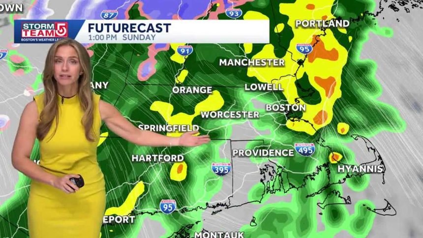
Sunday turns unsettled with rain and impact weather expected through the day.
Marathon Monday stays chilly and breezy, followed by a cold Tuesday morning before gradual improvement.
A milder, brighter pattern develops mid to late week with a few passing shower chances before more sunshine returns.
StormTeam 5 tools: Radar | Map Room | Alerts | Futurecast
StormTeam 5’s 7-day forecast:
- Saturday: Cooler with a mix of clouds. High of 54.
- Sunday: Rain with impact weather. High of 52.
- Monday: Windy and chilly with partial sunshine. High of 48.
- Tuesday: Cold morning with sunshine. High of 50.
- Wednesday: Chance of a shower with some sun. High of 58.
- Thursday: Mostly sunny and milder. High of 60.
- Friday: Clouds with late-day showers possible. High of 60.
Futurecast: Maps show what to expect in the coming hours
These maps are based on raw model data, which is updated automatically throughout each day and is subject to change.
StormTeam 5 has Boston’s only live radar scanning the skies over Massachusetts, 24/7.