


What if downtown San Antonio were cooler, greener and easier to walk through, even during the hottest months of the year? That’s the vision behind Centro San Antonio’s Trees Everywhere initiative, an effort to plant 1,000 trees over the next decade throughout the city’s urban core, creating a more resilient downtown.
But where should those trees go? That’s the question a team of UT San Antonio researchers from the Margie and Bill Klesse College of Engineering and Integrated Design is helping answer.
The team, made up of Farzad Hashemi, PhD; Fazel Khayatian, PhD; Esteban López Ochoa, PhD; Patrick Duhirwe, PhD, postdoctoral researcher; Haoming Qin, PhD, postdoctoral researcher and Parisa Najafian, PhD student, are combining the latest advances in geospatial analysis, remote sensing, field observations and microclimate monitoring to identify priority planting locations based on environmental benefits and site feasibility.
“For many cities around the world, urbanized areas can be warmer than surrounding less-developed areas, a phenomenon known as the urban heat island effect,” said Hashemi, assistant professor of architecture, coordinator of the Graduate Certificate in High-Performance Design and Sustainability (HPD&S) and director of the Climate-Sensitive Design Lab.
According to the U.S. Environmental Protection Agency (U.S. EPA), heat islands are urbanized areas that experience higher temperatures than rural areas due to the lack of green space and the high concentration of buildings and other infrastructure that absorbs and re-emits the sun’s heat.
“Downtown area buildings are taller and have more man-made construction like parking surfaces,” Hashemi said. “What makes that even worse in San Antonio is our downtown already has a lot of vacant lots that are being utilized as either public or private parking. So that makes downtown always hotter than other parts of the city. To mitigate these urban heat islands, our heroes are trees.”
Expanding San Antonio’s urban tree canopy offers benefits that extend far beyond shade.
According to the U.S. EPA, trees can cool surrounding neighborhoods, reduce energy costs, improve air and water quality, provide habitat for wildlife and help mitigate climate change by capturing carbon dioxide. Studies have also linked increased tree cover to improved physical and mental health outcomes, making urban forestry an investment in both environmental sustainability and community well-being.
Data-driven planting
However, trees can’t be planted just anywhere. Factors such as underground and aboveground utility infrastructure, long-term maintenance and available space can all influence where a healthy tree can grow. That’s where UT San Antonio’s researchers are helping.
As part of Centro San Antonio’s Trees Everywhere project, the team was charged with an initial task: identifying at least 200 priority tree-planting locations where new trees could provide meaningful benefits while meeting planting feasibility requirements. The team began its research in August and is expected to submit its recommendations by November 30.
While the team is using previously collected data as a baseline, they’ve also taken to the streets to collect their own data, including using sensor technology to better understand downtown’s current environment. A planned network of temperature and relative humidity sensors will also help establish baseline microclimate conditions for evaluating future changes following tree planting.
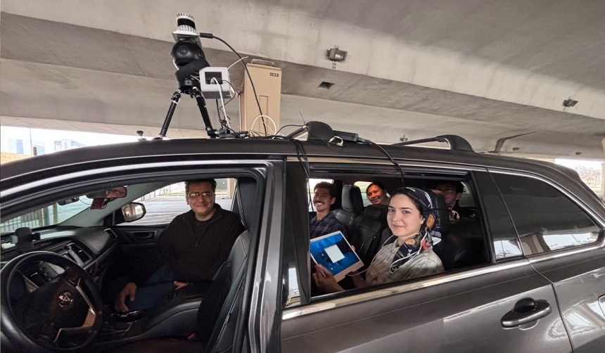
The researchers are using 360-degree street-level imagery and LiDAR (Light Detection and Ranging), which is a sensing method that uses rapid laser pulses to measure distance and build 3D models of the environment, said López Ochoa, associate professor and program lead of the Urban and Regional Planning program and associate director of the Sustainable Pervasive Urban Resilience Center. Qin is helping conduct the geospatial and environmental analysis, including gathering the land-surface temperature, shade/solar exposure and other related GIS data.
To collect data in areas inaccessible to larger vehicles, Najafian is riding through downtown on a sensor-equipped e-scooter she developed at the CSDL with support from the Scooter Lab at San Pedro I to document the locations and species of existing trees.
Using the collected data, the team will develop an integrated GIS-based spatial model and interactive mapping platform for Centro San Antonio’s Public Improvement District.
“We’re using many of the newest developments in the areas of computer vision and image segmentation to produce and analyze very fine-grained terrestrial imagery of the city of San Antonio,” López Ochoa said. “We’re going to have a detailed geospatial inventory of downtown streetscape features. It’s not just going to be trees, but we’re going to map features such as fire hydrants, bus stops and utility poles, including their dimensions where data are available. Currently, only autonomous vehicles are collecting this kind of data to better navigate the city. This initiative is proof that public universities can also, through the development of meaningful community partnerships, generate this data and use it to the greater public good, like where to plant trees.”
The spatial analysis will integrate environmental data, existing vegetation and infrastructure information to support tree-planting decisions, López Ochoa said. Although LiDAR mapping and the inventory of environmental and building assets is limited to the first task of research, the team hopes that they will be able to have a complete scan of the downtown Public Improvement District (PID) in the future.

The model will help researchers predict where new trees can provide the greatest cooling benefits while avoiding conflicts with existing infrastructure.
Khayatian, assistant professor in architecture and planning and director of the SentinelHive, and Duhirwe will then use the data to create an interactive dashboard, which Centro San Antonio will be able to use for tree-planting prioritization. Centro’s team will be able to adjust the criteria and priorities for new tree planting. These variables would include land surface temperature, accessibility, sidewalk width and drainage infrastructure.
“Once the priorities are adjusted, Python scripts will run in the backend to recalculate the priority scores and identify the highest-priority locations for tree planting,” Khayatian said. “The updated results will be displayed in the ArcGIS graphical user interface, and a list of prioritized locations will be exported as a spreadsheet to support decision-making.”
The dashboard can also be updated as conditions or planting priorities change, he said.
“The goal is not to only give Centro San Antonio the placement of the trees, but this baseline they can continue to use over the next 10 years,” Khayatian said.
Hashemi added that the trees could support economic development, reduce air and surface temperatures, improve energy efficiency in nearby buildings and make downtown more walkable.
Learn how a sensor-equipped e-scooter can help map existing trees and gather critical environmental data.
Giving back to the urban core
The Trees Everywhere initiative is one of several projects through which UT San Antonio researchers are working to improve downtown San Antonio.
Hashemi, López Ochoa and Khayatian’s are also lending their expertise to the Nueva Nueva initiative.
Through the Nueva Nueva initiative, the university is reimagining Nueva Street as a comfortable pedestrian corridor and key connection between Downtown Campus, San Pedro I and II and Hemisfair Park.
Beyond its impact on downtown San Antonio, the two projects give the students and emerging researchers opportunities to work alongside faculty on applied research, translating classroom knowledge into solutions for the community they are learning and living in.
Last semester, architecture and planning students incorporated the Nueva Nueva initiative into their studio coursework, developing redesign concepts and planning strategies for Nueva Street.
“We want our students to learn by doing real-world projects,” Hashemi said. “We guide them through the process, but they’re the ones getting the job done. With both Nueva Nueva and the Centro project, our students and early-career researchers are playing a major role in the work.”
For many years, UT San Antonio’s School of Architecture + Planning has been housed in downtown San Antonio. Most recently, the school moved to One Riverwalk Place.
“Our school has been a long-term resident of the downtown area, and we’ve always tried to be good stewards of the community,” Hashemi said. “These two projects give us the opportunity to give back. UT San Antonio is a long-term urban-serving institution and something that we also try to do as part of our job is taking care of our neighborhoods and our area.”