We’re staying cold and mainly dry for Tuesday evening through Wednesday. Wind chills will have temperatures feeling 5-10 degrees cooler than the actual temperature overnight, with lows in the upper 20s.
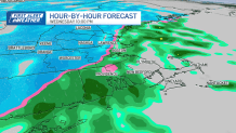
Wednesday, highs rise into the low 40s with winds shifting in from the southeast ahead of our next system, which enters by the evening. This wind shift is important because it will keep temperatures milder along the coast as the potential for rain and snow increases.
CLICK HERE for the updated timeline, snow maps and travel impacts for this week’s storm
Wednesday night into Thursday mid-morning, the best bet for solid snow accumulation is in the Berkshires and Worcester Hills. Coastal and low-lying areas will see mostly rain, with little to no snow accumulation expected east of Interstate 495 during the bulk of the system.
When will it snow in Boston, Worcester and the Merrimack Valley?

But as the cold air comes in Thursday afternoon, a few rogue snow squalls could bring in some light accumulations east of 495. The Merrimack Valley and Worcester have the potential for 1-3 inches, with the potential for up to 5 inches in higher terrain.
Snowfall total projections for Mass., NH

On the other side of this system, the coldest air of the season is ushered in, with gusty winds of 40-50 mph, especially across Cape Cod and the Islands. By Friday, lows in the teens and highs in the upper 20s to 30s.
A gradual warm-up through the weekend and the chance for more rain showers arrive by Monday.


