Thursday marks the midpoint of meteorological winter, and aside from our current stretch of relatively mild weather, this winter has been significantly colder than average. And thanks to an active jet stream, that means our region has seen more storms than normal since November, but with less intensity, and most of the snow has targeted interior sections of New England.
But a key shift in the jet stream’s position could unlock a potential nor’easter across our region later this week, right now targeting sometime Thursday. Also, another coastal storm may follow in its wake, possibly hitting the area Sunday night. Rain, snow, and strong winds are all on the table, but the question remains — who can expect rain and who can expect snow?
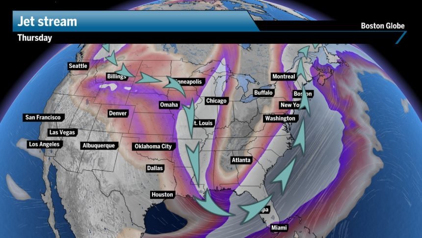
When the jet stream bends sharply to the south, making a U-shape, the chances for a developing storm on the eastern side are very high. Why? The strong jet stream winds aloft draw in warm and moist air from the south, all while increasing upper-level divergence. This means the strong air aloft will actually pull up air from the surface, creating lift and the development of a low-pressure system, meaning stormy weather.
The atmospheric picture is very dicey, and this far out is nothing more than a best guess. I lean on model trends and take pictures of different layers of the atmosphere. I then use what typically occurs geographically to put together the forecast.
This is a very dynamic and complex setup; any meteorologist out there who is stamping a forecast as complete this far out is just incorrect.
That said, the models right now are all over the place — with storm arrival time, precipitation type, and potentially a complete miss all in the equation. The main reason for the uncertainty is that a front will grind to a halt along the Northeast coast come Wednesday into Thursday. Will this allow for the coastal storm to simply march along the frontal boundary, or will it push out to sea by the time the coastal storm forms?
Right now, I’m leaning toward this storm being more of a miss to the south and east, meaning Boston and the rest of Southern New England could dodge this storm. If any precipitation is to fall, Boston and Coastal New England should stick to cold rain, while anywhere between 1 to 4 inches of snow can fall across the northern and western mountains, mainly from that more interior sliver of energy floating about.
Let’s check out what the models reveal.
The latest Euro forecast model suggests a more easterly track for this coastal system, sending the bulk of the storm out to sea and missing New England as it passes. Sure, there will be plenty of moisture in the atmosphere, but it doesn’t really mean much if it’s falling over the ocean.
Meanwhile, there will likely be a sliver of energy hovering over the interior portions of New England that may spark scattered light snow showers while funneling in colder air across the region. With this scenario, we could see light snow across the interior, with a couple of cold sprinkles in the Boston area.

The latest GFS model shows the storm also out to sea, but remaining closer to the shore than the Euro model. There is also a piece of energy hovering over New England that will spark widespread interior snow and coastal rain showers regardless, but the bulk of the storm will remain offshore.
This scenario will bring higher elevation snow, but totals will be modest. Boston and the coast would see perhaps a tenth to a quarter of an inch of rain.

Our own Globe Weather HQ model blends the Euro and GFS together with a few other details. It reveals the same track as the others: A coastal storm developing but with little pop. The storm hugs the coast, bringing rain to Boston and the coast while folks west and north see light to steady snow.
It won’t be until after the storm pushes into Canada that it really turns into an event.

Again, these models will change and will probably flip back to more of a closer pass for New England, especially if the interior sliver of energy can build enough to pull the coastal storm closer inland.
We are way too far out for snow totals or any of that talk, but as of right now, it looks like this storm is more for the fish than us New Englanders.
Second storm possibly takes shape Sunday night
We will also be keeping an eye on Sunday night as another coastal storm will attempt to organize, according to the Euro model.
Still nothing more than a guess, but there is the chance for rain and snow to cap off the weekend, and should this storm hug the coast, we’ll be talking about strong winds developing, checking off the box for a classic nor’easter.
But here’s the caveat: High-pressure diving south through the middle of the country may force this storm to have a late start in organizing, meaning Nova Scotia, instead of New England, may see a strong storm while we see more mild impacts.

Stay tuned!
Sign up here for our daily Globe Weather Forecast that will arrive straight into your inbox bright and early each weekday morning.
Ken Mahan can be reached at ken.mahan@globe.com. Follow him on Instagram @kenmahantheweatherman.