In what is likely to be the biggest winter storms in years for such a broad area of the U.S., heavy snow is forecast from the eastern slopes of the Rockies to the coastal Northeast. Travel shutdowns are anticipated.
A winter storm is forecast to bring ice and snow from Texas to the Northeast. Impacts will begin Friday evening in Dallas, expanding east to Charlotte, Atlanta, D.C. and NYC through Sunday.
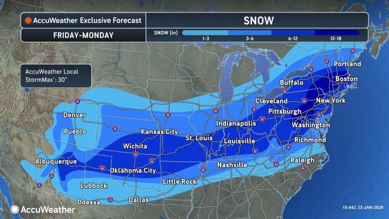
Enough snow to shovel and plow is forecast to spread from New Mexico and Colorado on Friday to Massachusetts and Maine by Sunday, impacting over 200 million people. It could be the biggest snowstorm in years with a large area having the potential to receive 6 to 12 inches of snow, with accumulations reaching 24-30 inches in the hardest-hit areas.
“It is rare that storms combine this much snow, ice and bitter cold over such a large area — a widespread travel-halting winter storm will stall daily life for days in large portions of the central and eastern U.S.,” AccuWeather Senior Vice President Evan Myers said.
Accumulating snow will fall along a swath of the central and eastern United States that extends for at least 2,000 miles and includes the major cities of Albuquerque, New Mexico; Denver; Oklahoma City; St. Louis; Nashville; Indianapolis; Cincinnati; Pittsburgh; Washington, D.C.; Baltimore; Philadelphia; New York City and Boston.
Snow will begin over eastern portions of Colorado and New Mexico as well as western portions of Kansas, Oklahoma and Texas on Friday and then expand eastward across the Mississippi and Ohio Valleys on Saturday. On Saturday night, the snow is forecast to reach the mid-Atlantic and the central Appalachians before spreading over much of New England on Sunday.
The arrival of Arctic air is setting up the storm. Without it, there might not be a storm or a massive zone of heavy snow. Across the northern tier of the Midwest, the air is already becoming too dry for steady snow to move up from the south.
The storm may last 36-48 hours in some areas before dry Arctic air finally overwhelms and turns off the snow later this weekend to early next week.
Chicago and Detroit will be on the northern fringe of the storm. Moisture from Lake Michigan may give part of the Chicago area a bump in accumulation, despite being on the northern edge.
The two-pronged storm is complex, with one part weakening as it moves toward the Tennessee Valley, while the other strengthens as it moves along the Atlantic coast.
Because warm air could move into parts of the Tennessee Valley and the East, some sleet or freezing rain may mix in at the height of the storm, limiting snowfall accumulations somewhat. This would still occur after a heavy snowfall, but it may prevent a widespread blockbuster snowstorm of 1-3 feet extending throughout the Interstate 95 corridor of the Northeast.
In the zone around central Maryland, the eastern panhandle of West Virginia and south-central Pennsylvania, a heavy rate of snow before and after any mixing of ice may compensate, hence AccuWeather’s forecast accumulation of 12-18 inches with an AccuWeather Local StormMax™ of 30 inches. Snowfall accumulations of 12-18 inches will also extend into southern portions of New York and southern New England.
If ice does not mix in over areas such as Washington, D.C., Philadelphia and New York City, snowfall may exceed the higher end of the average of 6-10 inches currently forecast. Some sleet and freezing rain are forecast to mix in over much of Virginia, central and eastern Maryland, all of Delaware, parts of New Jersey and southeastern Pennsylvania.
Travel conditions will deteriorate rapidly with streets, highways and runways becoming snow-covered during the first hour or so of the storm in many cases. Snowfall rates at the height of the storm may overwhelm road crews’ ability to keep roads open.
Similar to Chicago, the southern shorelines of Lakes Erie and Ontario may receive a boost in snowfall totals due to the added moisture from the nearby open waters.
Because of the massive scope of the storm, travel disruptions will continue well beyond the end of the storm as temperatures plummet into the teens, single digits and even below zero in some areas, which will reduce or prevent the function of ice-melting compounds.
Snow on some roads may be compacted by vehicles, making it more difficult to remove or drive on with full traction.
GET THE FREE ACCUWEATHER APP
•Have the app? Unlock AccuWeather Alerts™ with Premium+
Because the snow will fall at a heavy rate, at times 1-2 inches per hour in some locations, deicing operations and runway plowing at the airports may become futile, resulting in ground stops, flight delays and flight cancellations.
Thousands of flights are expected to be cancelled nationwide as crews and aircraft are displaced, even in areas where the sky is clear and the weather is dry. It may take days for the airline industry to fully recover and return to normal operations due to the massive scope of the storm.
More stories of interest:
Want next-level safety, ad-free? Unlock advanced, hyperlocal severe weather alerts when you subscribe to Premium+ on the AccuWeather app. AccuWeather Alerts™ are prompted by our expert meteorologists who monitor and analyze dangerous weather risks 24/7 to keep you and your family safer.