Monday night forecast
Atlanta is feeling a major “bite in the air” as temperatures crash from the 60s into the 20s overnight. We are tracking a dynamic storm system that could bring a few snow showers before a record-breaking warmup hits just in time for the first weekend of spring.
ATLANTA – A powerful late-winter storm system is ushering in a dramatic deep freeze across North Georgia, bringing snow flurries and a forecasted record-breaking drop in temperatures. While the winter weather will linger through mid-week, the FOX 5 Storm Team is tracking a major warm-up that will see spring arrive with temperatures hitting the 80s by Saturday.
What we know:
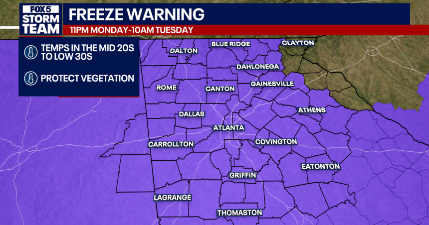
The National Weather Service has issued a Freeze Warning and a Wind Advisory for a massive portion of the state. According to the NWS, sub-freezing temperatures as low as 26 degrees are expected, with wind gusts reaching up to 35 mph.

What they’re saying:
The FOX 5 Storm Team is warning residents not to be fooled by today’s earlier rain. “The real stories are going to be the fridge, that overnight temps because everybody’s going to be down into the 20s,” said FOX 5 Storm Team Chief Meteorologist David Chandley.
FOX 5 Storm Team Meteorologist Jonathan Stacey noted the intensity of the cold front: “That cold air [is] firmly afoot, driven by some ferocious winds diving in from Canada. We’re not gonna shake this off so quickly.” Stacey warned that even with sunshine, temperatures on Tuesday could be nearly 20 degrees below average for this time of year.
Timeline:
Dangerous wind and cold will peak overnight before a gradual warming trend begins late Wednesday.
- Monday Night: Rain exits, but snow flurries continue through the evening with wind gusts up to 35-40 mph.
- Tuesday Morning: Temperatures bottom out in the 20s; wind chills will make it feel like the teens in some areas.
- Wednesday: A chilly start gives way to more moderate temperatures in the 50s.
- Friday: The vernal equinox arrives with a high near 76 degrees.
- Saturday & Sunday: Full spring weather arrives with sunshine and highs near 80.

Big picture view:
According to the FOX 5 Storm Team, a dynamic system fueled by mid-level energy and cold air from Canada has moved through the region. While the moisture is heading toward the Atlantic, a high-amplitude ridge will expand over the central U.S. later this week. This shift in flow will move the storm track north, allowing temperatures to climb rapidly by Friday.
Local perspective:
While snow flurries were spotted in the Atlanta metro, no travel impacts are expected as road temperatures remain in the 40s and 50s. However, the mountains of North Georgia, including Blairsville, could see up to 1 inch of accumulation on grassy and elevated surfaces. Blairsville is expected to hit a low of 19 degrees Tuesday night.

Why you should care:
The NWS warns that these conditions could lead to power outages from downed tree limbs. Additionally, the hard freeze will kill crops and sensitive vegetation. Residents are urged to wrap outdoor pipes, allow indoor faucets to drip, and bring pets inside to protect them from the sub-freezing temperatures.
By the numbers:
7-Day Forecast: Metro Atlanta
- Tuesday: High 47 | Low 31 (Sunny/Windy)
- Wednesday: High 55 | Low 35 (Partly Sunny)
- Thursday: High 67 | Low 45 (Mostly Sunny)
- Friday: High 76 | Low 52 (Sunny)
- Saturday: High 81 | Low 56 (Mostly Sunny)
- Sunday: High 81 | Low 54 (Sunny)
- Monday: High 78 (Sunny)
7-Day Forecast: North Georgia Mountains
- Tuesday: High 40 | Low 19
- Wednesday: High 50 | Low 28
- Thursday: High 62 | Low 38
- Friday: High 71 | Low 45
- Saturday: High 74 | Low 49
- Sunday: High 75 | Low 45
- Monday: High 71
What’s next:
Expect a very cold 48 hours as North Georgia grapples with this final winter blast. Once the freeze passes Wednesday morning, a significant and sustained warming trend will take hold just in time for the official start of spring on Friday.
Warming shelters
What you can do:
With temperatures forecast to drop well below freezing, local governments and nonprofit organizations across North Georgia have activated emergency warming centers to protect vulnerable residents from life-threatening wind chills. From Marietta to Ellijay, officials in Clayton, Douglas, and Gilmer counties, along with the cities of Atlanta and Palmetto, have opened overnight shelters beginning Monday to provide meals and refuge from the bitter cold.
In Atlanta, the city opened its warming centers Monday and will maintain operations through March 18. Centers at Central Park Recreation Center and Old Adamsville Recreation Center are open to all, while the Selena S. Butler Park and Recreation Center is designated for women and children only. Operations run from 8 p.m. Monday, March 16, until 11 a.m. Tuesday, March 17, and again from 8 p.m. Tuesday until 9 a.m. Wednesday, March 18. The city is providing transportation from the Gateway Center starting at 8 p.m. each night.
In Marietta, MUST Ministries Hope House at 1297 Bells Ferry Road is open to men, women, and children through Tuesday, March 17. Guests are asked to arrive by 8 p.m. to stay in the shelter, with dinner served at 5 p.m. and breakfast provided the following morning.
Douglasville’s warming center at the First United Methodist Church Youth Center, located at 6167 Priestly Mill Road, will operate from 7 p.m. to 9 a.m. Monday and Tuesday nights. While pets are not allowed inside the youth center, the Douglas County Animal Shelter is offering to pick up and house pets for the night and return them to owners the next day.
In Ellijay, the Gilmer County Warming Center at the Civic Center is open from 5 p.m. to 7 a.m. Monday and Tuesday. Unlike many other locations, this facility welcomes pets and will provide kennels and food upon arrival. Guests must arrive by 9 p.m.
Clayton County Fire and Emergency Services and the City of Palmetto have also activated their locations in response to the sub-freezing wind chills expected on March 16 and 17. In Palmetto, the warming center is located at the Palmetto Community Center at 595 Main St. and is open to all residents seeking a safe haven from the cold.
The Source: Information gathered from the FOX 5 Storm Team and the National Weather Service.