DENVER — Tonight, expect some light rain for NE Colorado into the late night hours. Any showers that develop should be on the light side, with brief gusty winds possible as pockets of virga pass overhead. In the mountains, light snow will continue off and on, but the heaviest accumulations are already behind us.
kmgh
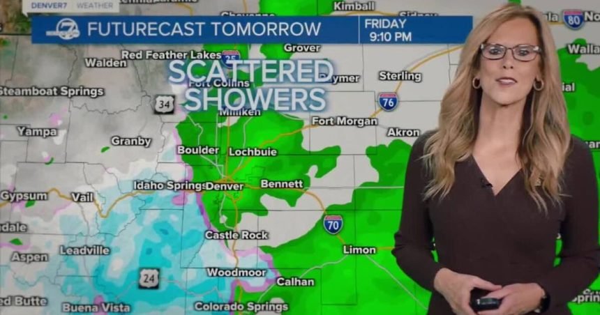
Friday brings another push of Pacific moisture as a trough slides across the Desert Southwest. Snow will pick back up in the higher terrain by late morning and become more widespread through the afternoon. The central mountains will be favored for accumulation, with a few inches possible by Friday night. Across the lower elevations, rain chances increase later Friday into early Saturday, but totals look modest. Areas above about 7,500 feet could see some wet snow early Saturday, while the urban corridor and plains mainly see light rain.
By Saturd
kmgh
Saturday afternoon, precipitation will be winding down from north to south in the mountains. Southern portions of the plains stand the best chance of picking up a little light rain/snow mix, while northern areas may see little to nothing. Temperatures through the weekend will remain above normal, and once this system exits, conditions will dry out quickly.
Sunday marks a noticeable shift in the pattern. High pressure rebuilds, skies clear out, and temperatures climb well into the 60s across the plains. While that will feel pleasant for mid-February, it comes with a downside. Humidity levels will drop into the teens during the afternoon, and breezy southwest winds will begin to increase, especially across South Park and the eastern plains. Elevated fire weather concerns will start to develop.
Rain heading our way for Friday, warmer this weekend
From Monday onward, fire weather becomes the main story. Strengthening southwest flow and a powerful jet overhead will bring even stronger winds, with gusts potentially reaching 45 to 60 mph by Tuesday across parts of the plains and foothills. Even where humidity values hover near, but not quite at, critical thresholds, the combination of warm temperatures, dry fuels, and several consecutive dry days will support at least elevated to locally critical fire weather conditions through midweek. We’ll be refining the details as we get closer, but it’s clear that after this brief shot at light precipitation, the focus quickly turns to wind and fire danger.
DENVER WEATHER LINKS: Hourly forecast | Radars | Traffic | Weather Page | 24/7 Weather Stream
Click here to watch the Denver7 live weather stream.