Up to 18 inches of snow will blanket parts of New York over Thanksgiving as a potent winter storm moves across the state.
On Wednesday morning, the Federal Aviation Administration (FAA) warned that low clouds could disrupt flights across New York, but a spokesperson told Newsweek that the FAA is “fully prepared to manage increased holiday traffic.”
Why It Matters
Several states are expecting winter weather this week, with NWS meteorologists warning of complicated travel conditions as millions of Americans take to the road or skies to visit family for the Thanksgiving holiday.
Nearly 82 million Americans plan to travel more than 50 miles from home this week for Thanksgiving. The busiest holiday travel day commonly falls on Wednesday, making the current weather forecasts particularly disruptive.
Weather is the greatest cause of flight delays, accounting for 62.6 percent, according to a report from the FAA.
What To Know
On Tuesday afternoon, the NWS office in Buffalo issued a warning of an incoming winter storm that would bring heavy snowfall across the western part of the state.
“Lake effect snow will start Wednesday evening and night northeast of the Lakes, and then shift southward Thursday and into Friday,” the post on X said. “A wet snow at first will make for difficult shoveling, with the snow becoming a bit drier Thursday night into Friday.”
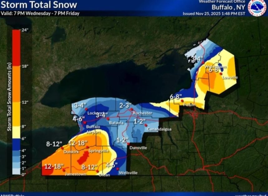
In a map included with the post, NWS Buffalo forecast snowfall totals as being up to 18 inches near Springville and Jamestown, up to 12 inches near Dunkirk, and up to 8 inches near Fulton, Lowville, and Watertown.
Widespread amounts of 3 to 4 inches are expected along the shoreline of Lake Ontario, with higher amounts near Lake Erie.
On Wednesday, the NWS Buffalo issued a lake-effect snow warning, a winter weather advisory, and other alerts.
“Heavy lake effect snow expected,” the warning said. “Total snow accumulations 12 to 22 inches in the most persistent lake snows. Winds gusting as high as 50 mph will produce blowing and drifting snow.”
What People Are Saying
NWS Buffalo in a forecast for the Lake Erie area: “Greatest storm total snowfall will focus across the higher terrain east of Lake Erie and well south of Buffalo. Early stages of the event will cross the Buffalo Metro area from north to south Wednesday night through early Thursday with some slushy accumulation.”
NWS Buffalo in a forecast for the Lake Ontario area: “Greatest accumulations will focus across the Tug Hill Plateau on Thursday, then southeast of the Lake Friday through Friday night.”
NWS in a Wednesday forecast: “Travel conditions will be challenging across the northern Plains, Great Lakes and east coast through Thanksgiving holiday weekend.”
What Happens Next
Snow will begin to fall in earnest on Wednesday night and continue through Thursday and into Friday, though the location might shift depending on the forecast. People living in the area are urged to follow the advice of local weather officials.