DENVER – Warm, windy and dry conditions across northeastern Colorado are fueling a high fire danger where a red flag warning goes into effect for a large portion of northeastern Colorado, including the Denver metro area on Friday morning.
High winds will continue to blow across northeastern Colorado Thursday including overnight into Friday where a high wind warning is also in effect.
The Denver7 news team is tracking the latest weather impacts and alerts in the Colorado weather blog below. Refresh this page for updates.
LINKS: Closings and Delays | Latest forecast | Radars | Traffic | Weather Page | 24/7 Weather Stream
Friday, January 16
8:31 a.m. | Xcel Public Safety Power Shutoffs| Xcel Energy announced it has enacted its planned power outages for approximately 9,000 customers in Larimer and Weld counties in anticipation of high fire danger Friday.
Xcel said crews would begin restoring power once the high winds and elevated fire risks subside.
6:59 a.m. | Louisville power outage | 2,431 customers are without power in the Louisville area, according to the Xcel Outage Map. It was not part of another round of ‘public safety power shutoffs’ or PSPS, planned Friday by Xcel Energy.
Xcel Energy
4:30 a.m. | Friday morning forecast | A cold front raced into Colorado overnight and it’s going to be about 20 degrees cooler Friday afternoon. We’re seeing wind gusts near 50 mph across the northeastern plains and it’s going to get even windier throughout the day.
High fire danger across all of northeastern Colorado
The strong winds and dry conditions will lead to high fire danger. A Red Flag Warning will go back into effect for much of northeastern Colorado Friday morning through the evening, with wind gusts near 70 mph. A High Wind Warning is in effect until 5 p.m. Friday for parts northeastern Colorado as winds continue to ramp up as the cold front surges into the state.
Thursday, January 15
5:10 p.m. | High wind forecast | The NWS in Boulder shared the below wind forecast that shows speeds and gusts through Saturday afternoon.

NWS Boulder
4:46 p.m. | Strong winds push semi off road | The driver of a semi in Jefferson County was not injured when high winds pushed the truck off the roadway, down an embankment and partially into Little Soda Lake along C-470, according to West Metro Fire.

West Metro Fire
4:41 p.m. | Xcel Energy planned power outages Friday | Around 9,000 Xcel Energy customers in Weld and Larimer Counties will be impacted by a Public Safety Power Shutoff (PSPS) on Friday starting at 8 a.m.
Xcel Energy will shut off power in these areas as high winds and dry conditions will fuel a high fire danger in northeastern Colorado. The PSPS will “lessen the risk of wildfire and protect public safety,” wrote Xcel Energy.
“Xcel Energy recognizes a significant number of customers are likely to experience an outage and that such events are highly disruptive. The company’s goal is to limit impacts as much as possible while effectively managing high wildfire risk and will continue to communicate updates through the event, including outage and restoration information,” added Xcel Energy.
Denver7 News will monitor power outage impacts in Colorado on Friday.
4:36 p.m. | Colorado schools cancel classes | Denver7 has learned five schools in Larimer and Weld Counties will cancel classes Friday as Xcel Energy will conduct planned power outages due to critical fire conditions.
These are the schools impacted:
- Timnath Elementary, Timnath Middle-High School in Larimer County
- Cache la Poudre Elementary and Cache la Poudre Middle School
- Ridgeline Middle School in Weld County
You can read more about the the school closures and planned power outages on Friday at this link.
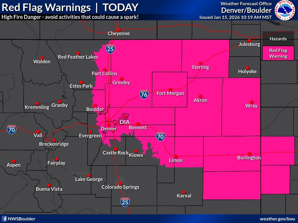
4:20 p.m. | Red flag warning for Friday | Portions of the I-25 corridor, Denver metro area and northeastern plains and northern foothills will again be under a red flag warning for a high fire danger on Friday. The NWS map below shows areas impacted.
“The vast majority of wildfires are caused by human negligence. Please abide by any fire restrictions, and practice common sense around equipment that may produce sparks,” wrote NWS forecasters.

NWS Boulder
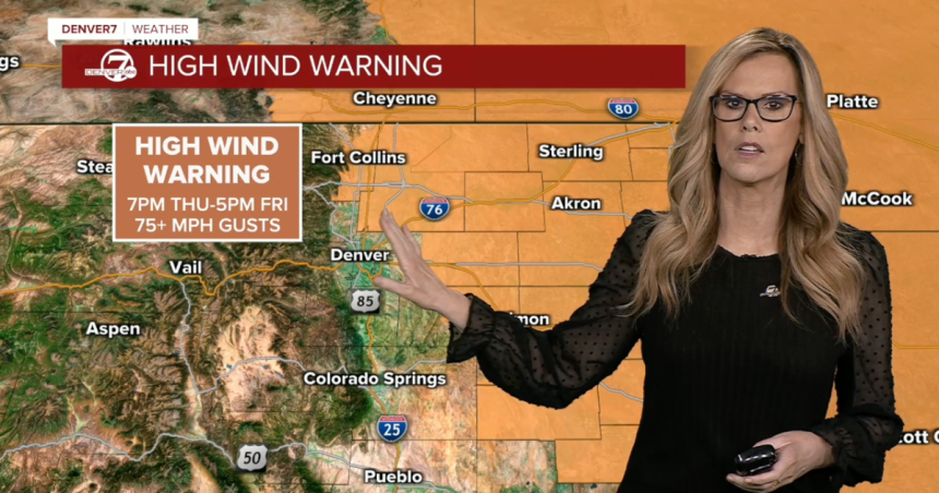
The National Weather Service (NWS) in Boulder has issued several high wind warnings for northeastern Colorado starting Thursday evening where gusts in some areas could reach 70+ miles per hour as a cold front rolls through.
3:30 p.m. | High wind warnings | The National Weather Service (NWS) in Boulder has issued several high wind warnings for northeastern Colorado starting Thursday evening where gusts in some areas could reach 70+ miles per hour as a cold front rolls through.
For the Fort Collins, Fort Morgan, Greeley area the high wind warning goes into effect at 7 p.m. through 5 p.m. Friday, said the NWS. Additionally, northeastern Colorado counties will go under a high wind warning at 7 p.m. for “sustained speeds 30-45 mph — peak gusts 60-70 mph.”
“Gusty winds will blow around unsecured objects and a few power outages may result. Strong winds will likely lead to rapid fire growth of any new fire,” wrote NWS forecasters. Below are the counties included in the high wind warning, which as of Thursday afternoon does not include the Denver metro.

NWS Boulder
3:20 p.m. | Red flag warning | Low humidity, warm temps and high winds are fueling critical fire conditions in northeastern Colorado, including in Denver. A red flag warning remains in effect until 6 p.m. Thursday for the below counties.
Denver7
Click here to watch the Denver7 live weather stream.