Snow is transitioning to a messy mix across the board Sunday morning. Mixing brings in the potential for freezing rain, sleet, and rain in spots falling on wet, slushy snow. This could lead to slippery roads and challenging travel conditions, especially in areas away from the coast where temperatures remain in the upper 20s to low 30s.

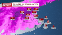
Ice accumulations in northern Worcester County and southern New Hampshire could get near 0.25 inches, which would bend tree limbs and create tricky travel on untreated roads. By midmorning, most spots Boston and south will see plain old rain as temperatures rise above freezing.

Sunday night into Monday, a strong cold front will sweep through, rapidly dropping temperatures into the 20s and causing winds to pick up. In anticipation of the wind, there is a high wind watch. Wind gusts Monday will be up to 50 mph, which could cause issues and power outages, especially inland over Worcester County, where ice accumulations are possible.

Any leftover moisture on roads and sidewalks early Monday will freeze quickly, creating a slippery Monday commute. Overall, the storm will taper off early Monday, leaving behind a cold, gusty start to the workweek.
Our next chance for winter weather is Thursday into Friday, with snow possible. The track of this storm will make a big difference, so we will watch it closely in the coming days.