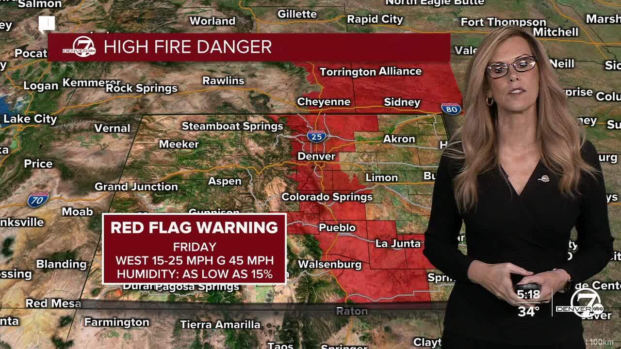
DENVER — Tonight: Strong winds ramp back up overnight, especially in the mountains and foothills. Winds will steadily increase late tonight with powerful west winds developing by early Friday morning. Gusts of 60 to 80 mph will be common in the high country, and the windiest ridges and peaks could top 100 mph. Lower foothills may stay quieter for part of the night, but conditions will deteriorate toward daybreak as winds continue to ramp up. A High Wind Warning is in effect until 8pm Friday night for winds between 60-100 mph for the foothills and the high country. The Denver metro is under a Red Flag Warning for high fire danger on Friday.
kmgh
Friday: This will be a very windy, very warm, and very dry day. Strong downsloping winds will roar through the foothills and into parts of the urban corridor, with the highest risk for damaging gusts along the CO-93 corridor from Lyons through Boulder and into Jefferson County. Gusts over 100 mph are possible in favored areas, while some locations just east of the I-25 corridor may see much less wind. Temperatures will soar to near record levels, humidity will crash below 15 percent, and fire danger will be extreme with red flag conditions likely lasting well into the evening.
kmgh
Friday night: Winds should gradually ease after sunset, but they won’t shut off completely. There’s a decent chance that gusty winds briefly spread farther east overnight, including parts of the I-25 corridor and metro Denver, even in places that were calmer during the day. Fire weather concerns will linger into the evening due to poor humidity recovery before cooler air finally starts to creep in.
Saturday: Snow returns to the mountains, especially north of I-70, with light to moderate accumulations through the day. Roads will become slick along and north of I-70, including stretches from Georgetown to Vail Pass, and travel impacts are likely in the northern mountains. On the plains, a weak cold front moves through with more clouds and a small chance for light rain or sprinkles, but most lower elevations stay mostly dry with highs still in the 50s.
Dangerous winds return on Friday, much warmer
Looking ahead: Mountain snow continues Saturday night into Sunday, though lighter by Sunday, with the best totals in the northern mountains. The plains stay mild and mostly dry this weekend. The weather does look excellent for the Bronco game on Sunday- with highs in the 50s and a lot less wind.
Next week turns unusually warm and dry, feeling more like spring than winter, with highs climbing into the 60s and possibly near 70 early in the week. Any meaningful mountain snow chances look to hold off until later next week, and even then confidence is low for now.
DENVER WEATHER LINKS: Hourly forecast | Radars | Traffic | Weather Page | 24/7 Weather Stream
Click here to watch the Denver7 live weather stream.