



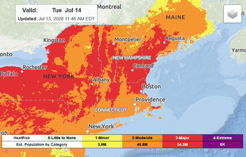
High temperatures across the state will be followed by severe storms on Tuesday in the Adirondack Mountains, with high winds, hail and even tornadoes possible, meteorologists said Monday.
A heat advisory will be in effect from 11 a.m. to 8 p.m. Tuesday in the Hudson Valley, Capital Region and the northernmost part of the state. Temperatures are expected to climb to around 96 degrees in the Albany area, with humidity making it feel closer to 102 degrees, said Samantha Lankowicz, a meteorologist with the National Weather Service in Albany. Areas around Poughkeepsie will be around 95 and feel like 100.
The cause of the high heat and humidity is a “heat dome,” a strong, upper-level high-pressure system that traps warm air over a region, Lankowicz explained. This particular heat dome is expected to slide eastward from the central part of the United States to the Northeast.
In the northern part of the state, outside of higher terrain, highs on Tuesday will be in the upper 90s and feel around 95 to 103 degrees, said Adrianna Kremer, meteorologist with the National Weather Service in Burlington, Vt. Those high temperatures will help drive a cold front that will bring thunderstorms in the evening through overnight.
“We can expect all different hazards tomorrow,” Kremer said. “But the primary threat is going to be damaging winds.”
Gusts of 70 mph or higher are possible, as well as quarter-sized hail and possibly tornadoes. Heavy rain could also cause flooding.
There will also be a marginal risk in the Glens Falls area for severe weather, but storms will otherwise stay north of the Capital Region on Tuesday, Lankowicz said.