SAN ANTONIO – Mainly sunny skies turn partly sunny this afternoon as a weak frontal boundary draped across the area gives us a chance of a few pop-ups showers or storms this afternoon. Brief heavy downpours are possible. This will actually be the best rain chance areas west of San Antonio have in the days ahead. Upper 90s, humid.
CLICK HERE to track Beryl in our interactive hurricane center…
Partly to mostly sunny Sunday with only an isolated shower chance, primarily southeast. Upper 90s.
On Monday, Beryl’s impact will be felt—a sharp cutoff between tropical rain, and no rain at all. Western areas will stay hot and dry, with temps near 100 near the Rio Grande. San Antonio will be right on the edge of heavy tropical rain, and no rain. Likely to see scattered showers and storms from Beryl’s outer bands. Highs near 90. Eastern counties will experience heavy rain, and tropical wind gusts to 60mph at times.
Latest on Beryl
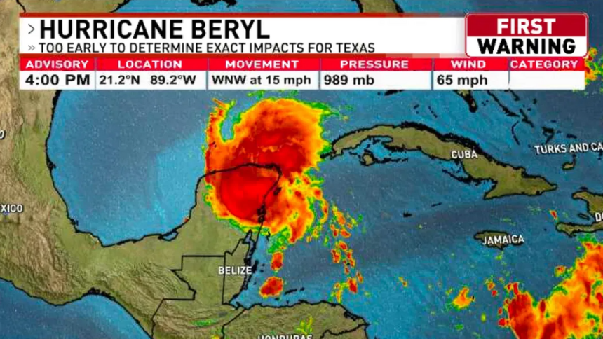
Beryl has become slightly more organized since Saturday morning. The storm is still fighting wind shear, dry air, and Saharan dust. Wind shear is forecast to back down by Sunday morning allowing Beryl to begin to intensify back to hurricane strength.
The storm is tracking northwestward and will likely hold this course until tomorrow afternoon. A turn to the north is expected Sunday afternoon and make landfall near Pt. O’Connor, Texas. The storm will continue northward and weaken.
Residents along the lower and middle Texas coast are facing an increasing risk of damaging hurricane-force winds and storm surge late Sunday into Monday. The National Weather Service has issued hurricane storm surge watches and a hurricane warning for the region as the tropical system approaches. Flash and urban flooding are also likely as the storm continues to move closer to the coast.
As of the latest advisory, the storm is approximately 385 miles southeast of Corpus Christi, with maximum sustained winds of 60 mph and moving west-northwest at 13 mph. A hurricane warning is now in effect for the Texas coast from South Padre Island to Beaumont. A storm surge warning is in effect from Corpus Christ to Galveston.
Forecasters predict that the storm will likely reach hurricane strength before making landfall on Monday morning. Coastal residents are urged to prepare for potential evacuations and to stay informed through local authorities and weather updates. The combination of hurricane-force winds, storm surge, and flooding poses a significant threat to life and property along the Texas coast.
Beryl moves into the Gulf of Mexico after battering Mexico’s Yucatan Peninsula, takes aim at Texas
TULUM, Mexico (AP) — Beryl moved into the the Gulf of Mexico Friday and took aim at the south Texas coast after battering Mexico’s Yucatan Peninsula. Texas officials issued disaster declarations and urge coastal residents to prepare as the storm headed their way.
Beryl, the earliest storm to develop into a Category 5 hurricane in the Atlantic, caused at least 11 deaths as it passed through the Caribbean islands earlier in the week.
The storm’s center Friday afternoon was in the Gulf just off Mexico, about 615 miles (995 kilometers) southeast of Corpus Christi, Texas. It was moving west-northwest at 13 mph (about 20 kph) with maximum sustained winds of 60 mph (95 kph), the hurricane center said.
Some Texas counties have already issued voluntary evacuation orders in low-lying areas, and Texas officials urged coastal residents to prepare.
Along the Texas coast in Corpus Christi, city officials announced it had distributed 10,000 sandbags in less than two hours Friday, exhausting its supply.
“This is a determined storm that is still strong,” Texas Lt. Gov. Dan Patrick said at a news conference.
Patrick issued a pre-emptive disaster declaration for 40 counties that allows state and local authorities to start planning and contracting for response.
Nim Kidd, chief of state emergency operations, said oil companies have started moving employees off rigs along the coast that may be in the path of the storm.
Northeastern Mexico and southern Texas were already soaked by Tropical Storm Alberto just a couple of weeks ago.
Beryl spread destruction in Jamaica, St. Vincent and the Grenadines, and Barbados this week. Three people have been reported dead in Grenada, three in St. Vincent and the Grenadines, three in Venezuela and two in Jamaica, officials said.
The head of Mexico’s civil defense agency, Laura Velázquez, said Beryl hadn’t caused any deaths or injuries there and that “damages were minor,” though tens of thousands of people remained without power.
Tulum was plunged into darkness when the storm knocked out power as it came ashore. Screeching winds set off car alarms across the town. Wind and rain continued to whip the seaside city and surrounding areas Friday morning. Army brigades roved the streets of the tourist city, clearing fallen trees and power lines.
After seeing Beryl tear through the Caribbean, 37-year-old Lucía Nagera Balcaza was among those who stocked up on food and hid away in their homes.
“Thank god, we woke up this morning and everything was all right,” she said. “The streets are a disaster, but we’re out here cleaning up.”
Before the storm hit Mexico, official had set up shelters in schools and hotels. When the wind began gusting over Tulum’s beaches Thursday, officials on four-wheelers with megaphones rolled along the sand telling people to leave and authorities evacuated beachside hotels. Sea turtle eggs were even moved off beaches threatened by storm surge.
Tourists also took precautions. Lara Marsters, 54, a therapist visiting Tulum from Boise, Idaho, said she had filled up empty water bottles from the tap.
“We’re going to hunker down and stay safe,” she said.
While many in the Yucatan Peninsula took a deep breath, Jamaica and other islands ravaged by the hurricane were still reeling. As of Friday morning, 55% of Jamaica still without electricity and most of the country was without running water, according to government figures.
“I know some of you are experiencing discomfort and displacement, and I want to assure you that the government will move as quickly as we can to get you the help you need,” he said.
Earlier in the week, the hurricane damaged or destroyed 95% of homes on a pair of islands in St. Vincent and the Grenadines, jumbled fishing boats in Barbados and ripped off roofs and knocked out electricity in Jamaica.
On Union Island, part of St. Vincent and the Grenadines, a man who identified himself as Captain Baga described the storm’s impact, including how he had filled two 2,000-gallon (7,570-liter) rubber water tanks in preparation.
“I strapped them down securely on six sides; and I watched the wind lift those tanks and take them away — filled with water,” he said Thursday. “I’m a sailor and I never believed wind could do what I saw it do. If anyone (had) ever told me wind could do that, I would have told them they lie!”
The island was littered with debris from homes that looked like they had exploded.