The weather pattern is both cold and wintry through the weekend. Our focus in the short-term is a vigorous weather system racing through early Thursday.
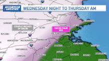
We’ll see the precipitation break out Wednesday night after 10 p.m. With steady south winds blowing across the Commonwealth, towns and cities west of Bedford, Hopkinton, and north of Topsfield have the best chance of seeing snow. In fact, for the Greater Worcester area and northern Worcester County, this will be the first significant snow of the season, with the possibility of a few inches of accumulation.
Will it snow in Boston?
As the graphic shows, between interstates 495 and 128, we can expect a blend of rain and snow. Elsewhere, it’s all rain along the coast, for Greater Boston, the South Shore, Cape and Islands. Expect slow travel into Thursday morning as the storm starts to exit. We’ll see a pause after 9 a.m., with the final leg of the storm moving through by early afternoon.

Snow squalls could impact travel
This final act could prove to be the more interesting of the two. We could see a band of snow squalls move through with reduced visibilities and a coating of snow (or maybe an additional inch in central Massachusetts) in some spots. Gusty winds will accompany any squalls, and we’ll see a marked temperature drop after they pass. Keep an eye to the sky if you’re traveling and be prepared for a quick coating on the roads.
Temps plummet Thursday night as the wind continues to howl. By morning, we should see widespread teens and 20s with wind chills near 0! This cold will stifle temperatures into the weekend.
Next up, a warmer storm may approach late Monday and Tuesday.


