Christmas night concluded with a gusty wind as colder modified Arctic air moved into the region. Temperatures were already below freezing before 6 p.m. after reaching near 40 earlier on Christmas Day.
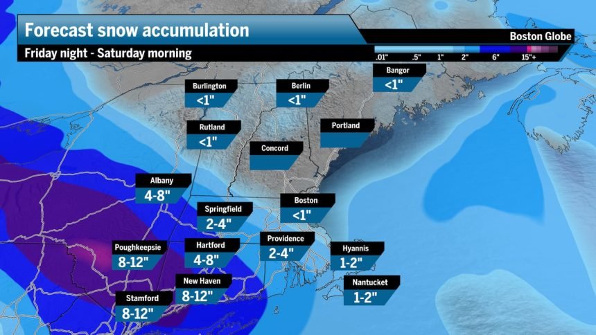
The active weather pattern continues and there are winter storm warnings posted for New York City, southern Connecticut, and parts of northern New Jersey, where a significant winter storm is expected Friday afternoon into the overnight. It looks like generally 4 to 8 inches of snow is going to fall in the heaviest hit areas, with temperatures in the 20s. It’ll be a light, fluffy snow for that region and if New York City receives more than 4 inches, it will be the city’s largest storm since January of 2022.
The upper-level winds are going to take most of that snowfall south of Boston, although late Friday night and into the first few hours of Saturday, the northern shield of that could produce a coating to a couple of inches, mostly south of the Mass Pike and southwest of Boston. A little bit of a wobble north would bring some snow north of the Mass Pike, while a little wobble south would keep all the snow out of Boston. Needless to say, when you get up Saturday morning, you might have to shovel a little bit or just brush off the car.
A winter storm warning is in effect for western Connecticut, and winter weather advisories for Western Massachusetts and central Connecticut for Friday night into early Saturday.


It will be cold, with highs in the 20s across Southern New England, and the teens up north.

Weekend: Possible freezing rain Sunday
Saturday will feature clearing skies with temperatures in the 20s for a cold afternoon. Then it’s back to the teens Saturday night.
Sunday brings sunshine to start the day, but clouds to finish. Temperatures will get above freezing as somewhat milder air is flowing north.
Late Sunday evening, precipitation will overspread the area from the south. Temperatures will be cold enough at the surface that even though the snowflakes will be melting above us, as that rain hits the ground, it could freeze for a few hours. The highest likelihood of freezing rain is going to be west of Route 128, but if you are planning on traveling later Sunday evening, stay tuned to the latest forecast as the roads could be quite hazardous.
This weather system that’s going to bring the messy weather Sunday night is heading up through the Great Lakes. When windstorms take that path, they pull much milder air in from the south, which is why this is not going to be a snowstorm even for Northern New England. As a matter of fact, I think even rain will occur across portions of ski country Sunday night and early Monday.
Colder air will quickly sweep in behind this weather system for a return to below freezing temperatures for much of next week as we conclude 2025.
Greater Boston: Sunshine followed by increasing clouds. Temperatures in the 20s. Clearing after an early snow shower Saturday. There could be a coating to an inch of snow.
Central/Western Mass.: Sunshine with afternoon clouds and some overnight snow showers. Temperatures in the lower 20s. There could be a coating to an inch or two of snow
Southeastern Mass.: Look for sunshine with a few afternoon clouds and temperatures in the 20s. Look for a coating to an inch of snow.
Cape and Islands: Sunshine is followed by some clouds. There will be a little bit of possible overnight snow shower activity. There could be a coating to an inch.
Rhode Island: Increasing clouds, with a high near 25. Snow Friday night, accumulating 1 to 2 inches.
New Hampshire: Look for plenty of sunshine with temperatures in the teens to the near 20. Cold this weekend.
Sign up here for our daily Globe Weather Forecast that will arrive straight into your inbox bright and early each weekday morning.