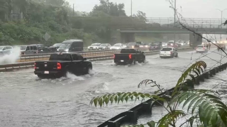
Parts of Interstate 93 in Milton and Quincy, Massachusetts, were underwater Thursday morning as heavy rain pushed through the region, prompting flash flood warnings for several counties in the Bay State, as well as parts of Rhode Island and Connecticut.
Click here for active weather alerts
Massachusetts is drying out after flash flooding turned the morning commute into a mess.
Massachusetts State Police and the Massachusetts Department of Transportation announced lane closures due to the flooding, initially including I-93 southbound at Exit 3 in Milton, and I-93 northbound at Exit 8 and the I-93 northbound HOV lane in Quincy.
They later said I-93 northbound and southbound were fully closed at Exit 3 in Milton due to the flooding.
State police had issued a traffic alert just after 8 a.m., saying I-93 was experiencing flooding as a result of significant rainfall.
A section of Interstate 93 south in the Milton area was shut down on Thursday morning after 2-4 inches of rain flooded the highway.
Police were asking everyone to avoid the area of Exit 3 (Houghton’s Pond/Ponkapaug Road), as Milton and Canton police assisted state police with diverting traffic.
MassDOT said in an updated statement around 10 a.m. that they have crews working to address areas, including the Southeast Expressway, that were impacted by Thursday morning’s flash flooding. They strongly encourage drivers to proceed with caution and be mindful of flooded roadways and to minimize travel as much as possible until the flooding subsides.
“At present, I-93 northbound is currently closed at exit 8, and I-93 southbound is currently closed at exit 10 in Quincy. I-93 northbound and southbound have reopened at exit 3 in Milton,” MassDOT said.
Why did we get so much rainfall so quickly, causing heavy flooding on the highways? Meteorologist Pamela Gardener explains, and previews a drier stretch ahead for the weekend.
Shortly after 11 a.m., MassDOT said all lanes of I-93 in Quincy had reopened. All lanes of I-93 had reopened as of 2:30 p.m.
Video from the area showed the roadway almost completely underwater, appearing more like a river than a busy highway during the weekday morning commute.
Some areas of Massachusetts, including Weymouth and North Hingham, had already received over six inches of rain as of 7:30 a.m. Thursday, with the heaviest bands of showers just to the west of Weymouth and right along I-95 into Braintree, Brockton and Quincy.
Heavy flooding was also reported in parts of Braintree on Thursday morning.
Braintree police said Union Street, The Landing and Granite Street by Wood Road were experiending flooding. They urged motorists to stay off the roads or seek alternate routes if possible until the flash flooding subsided.
Cohasset police said Route 3A at Lower King was closed due to flooding, and they urged motorists to avoid the area.
And in Walpole, street flooding was reported on East Street at Elm Street under the railroad bridge, on Common Street near Washington Streeet and on School Street in front of Town Hall.
The National Weather Service said the flash flood warning including Milton, Quincy and Randolph is in effect until 11:15 a.m. There’s a considerable flash flood threat ongoing there, where thunderstorms producing heavy rain across the area has brought 2 to 4 inches of rain.
Downpours with an expected rainfall rate of 1 to 2 inches per hour will continue through mid-morning, and additional rainfall amounts of 1 to 2 inches are possible.
Flooding was also reported in Braintree, where Granite Street was closed near Wood Road right, next to the South Shore Plaza. At least two cars were being towed after water possibly got into the wheelbase, impacting the electronics.

NBC10 Boston meteorologist Tevin Wooten says the rain is just ramping up and won’t taper off until this afternoon.
Once we get through this, Wooten says we should hit a drier spell.
Tevin Wooten is tracking heavy rain pushing through the region this morning.