Summer is back — well, at least for Monday. We’re tracking near-record high temperatures in the Greater Boston area, but don’t get used to it. Big changes are coming this week!
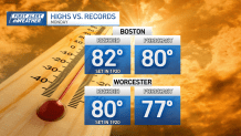
Boston tied its record high at 82 degrees – first set in 1920 – by Monday afternoon.
NBC10 Boston
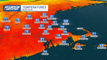
For Worcester, the current record is 80 degrees set back in 1920 as well. The city was very close as of 3:30 p.m., with temps at 79.
Otherwise, we’ll see a good deal of sunshine to enjoy any errands or outdoor activities with the family through the day.

One thing to keep in mind – with all the dry weather we’ve seen here in the Commonwealth lately, there is an elevated fire risk Monday. Low relative humidity values, the lack of rain and gusty southwest winds could create dangerous fire conditions. So, be careful when handling or disposing of ignition sources (grills, cigarette butts, etc.) through the day.
Low temperatures will drop into the mid 50s under mostly clear skies.
On Tuesday, our temperatures will fall just a tad as our winds shift to the east-southeast. So, communities along the coast will see temperatures near 70 degrees. Areas away from the water will have highs in the low to mid 70s. We’ll see more sunshine.
A few more clouds will push into the region on Wednesday ahead of a cold front. The front will slide through the area Thursday. While a sprinkle is possible late Wednesday night into Thursday, much of our area will be dry. But our high temperatures will tumble.

Highs will be in the upper 50s to near 60 on Thursday. By Friday, highs will sink into the mid 50s. And after a slight warmup into the 60s on Saturday, another front will take temperatures back into the mid 50s on Sunday.
We’re also watching Oscar in the tropics. The storm will continue to impact Cuba and the southeastern Bahamas with heavy rain and wind. Oscar is not forecast to impact the U.S.


