HOUSTON, Texas (KTRK) — Beryl made landfall at about 4 a.m. Monday in Matagorda County as a Category 1 hurricane with winds of 80 mph. Beryl has moved north as a tropical storm and out of southeast Texas. Conditions will continue to improve into the evening.
Beryl left behind significant flooding and damage across the region. Isolated showers were still possible Monday evening, but the second half of the day will be much drier. Clouds will linger overnight, with temperatures falling into the low 70s by Tuesday morning.
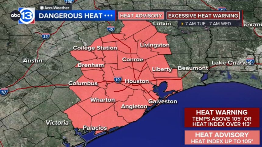
With temperatures rebounding into the low 90s and the humidity high, heat index values will make it feel like the triple digits in the afternoon. That’s why a Heat Advisory is in place for Tuesday.
How long will flooding last?
With between five to 10, upwards of 12, inches of rain falling within less than 12 hours in southeast Texas, it will take a minute for all this flooding to clear streets, roadways, and highways Monday.
Floodwaters need to flow through our bayous, creeks, and streams, causing street flooding.
Additionally, Galveston Bay experienced a surge between two and six feet, which will initially limit floodwaters from draining into the bay. That said, area floods and street flooding could linger Monday evening, with conditions improving by Tuesday morning. Debris could also be on roads and must clear before roads are passable.
What about tropical storm or hurricane-force winds?
Storm-force winds could linger through Monday evening as Beryl tracks northward across southeast Texas. Those winds will gradually taper off Monday evening. Power outages from tree damage and those powerful winds could linger through the week.
What does the rest of the week look like?
There’s still the opportunity for scattered tropical downpours on Tuesday in the wake of Beryl. Generally, though, the forecast does look drier for the rest of the week. This is good news for those floodwaters as they can drain through the watershed and out to Galveston Bay throughout the week. Unfortunately, those Houston summertime temperatures will be back in the 90s all week long, so those without power will battle some steamy conditions. A Heat Advisory has been issued for most of southeast Texas and begins at 7 a.m. Tuesday and lasts until 7 a.m. Wednesday and could be extended day by day throughout the week.
13 ALERT RADAR MAPS:
Montgomery/Walker/San Jacinto/Polk/Grimes Counties
Fort Bend/Wharton/Colorado Counties
Have weather tips, videos, and photos?
Send it to ABC13 using the form below. If you have a video or photo to send, terms of use apply. If you don’t, just hit ‘skip upload’ and send the details.
https://simplepost.abcotvs.com/simplepost/?storyId=15042213
Copyright © 2024 KTRK-TV. All Rights Reserved.