The KHOU 11 weather team is keeping an eye on the storm as it nears the Texas Gulf Coast.
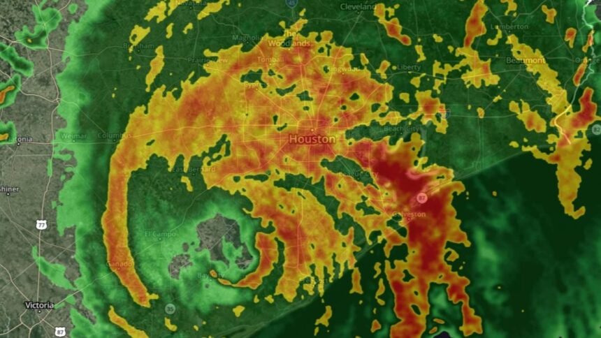
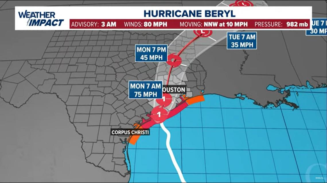
Winds have weakened to 75 mph. The storm continues to move north-northwest at 12 mph. The storm is 20 miles west of Houston.
The worst of the storm is expected from now until 2 p.m. for much of Southeast Texas. Conditions will rapidly decline at the coast just after midnight. The City of Houston should see the worst impacts from rain and wind between now and 10 a.m. Areas north of Houston should expect the worst from 5 a.m. to 2 p.m.
Active weather alerts
- A Flash Flood Warning was issued for Harris County, northwestern Chambers County, southwestern Liberty County, and southern Montgomery County until 11 a.m.
- A Flash Flood Warning was issued for Montgomery, Chambers, Galveston, Liberty, and San Jacinto counties until noon.
- A Flash Flood Warning was issued for Harris County, northwestern Chambers County, southwestern Liberty County, and southern Montgomery County until 9:30 a.m.
- A Flash Flood Warning was issued for Harris County, northeastern Brazoria County, southwestern Chambers County, northeastern Fort Bend County and northwestern Galveston County until 11 a.m.
- A Flash Flood Warning was issued for Harris County, northeastern Brazoria County, southwestern Chambers County, northeastern Fort Bend County, and northwestern Galveston County until 8 a.m. At 4:54 a.m., Doppler radar and automated rain gauges indicated thunderstorms producing heavy rain across the warned area. Between 2 and 4 inches of rain have fallen. Additional rainfall amounts of 1 to 3 inches are possible in the warned area. Flash flooding is ongoing or expected to begin shortly.
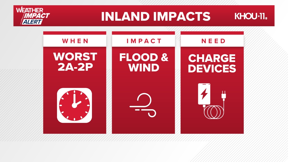
The KHOU 11 Weather Team issued a Weather Impact Alert Day for Monday as Beryl approached. The biggest impact will be from now until 1 p.m. on Monday.
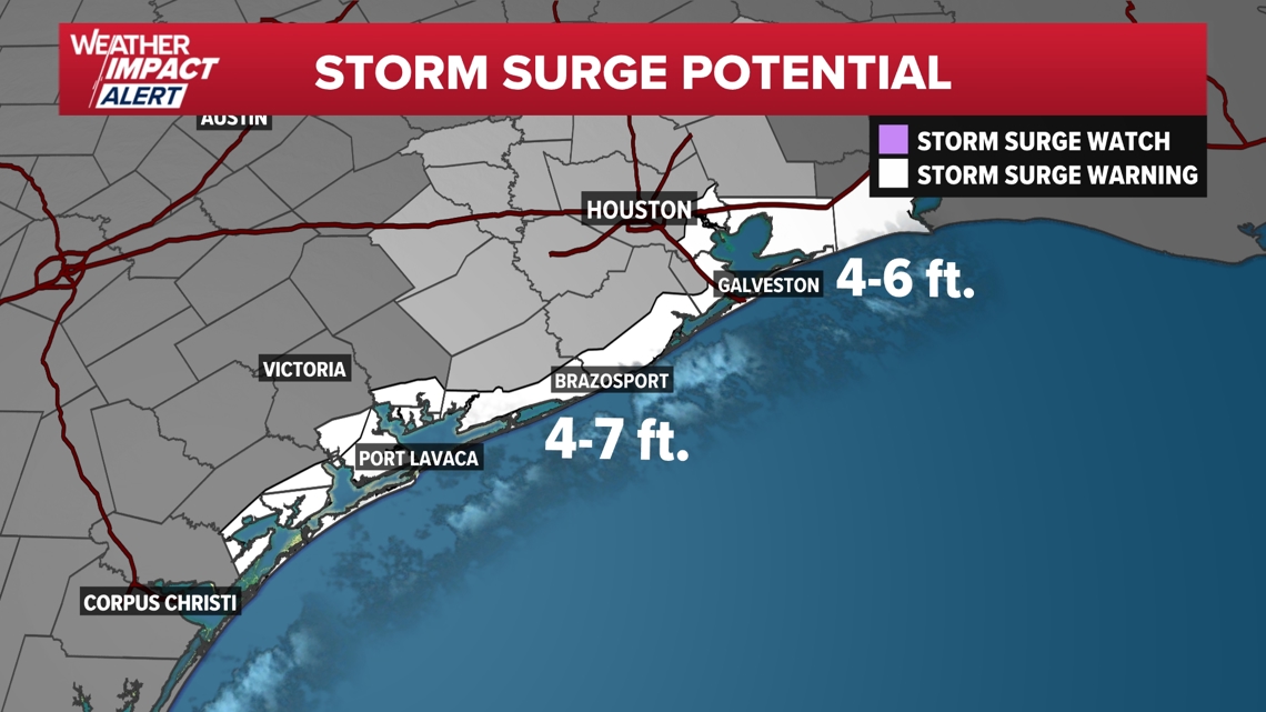
Storm surge forecasts have increased for the entire upper Texas coast, including Galveston. Water rises of up to 7 feet will be possible along coastal areas. Galveston could see a storm surge of up to 6 feet, including Galveston Bay. As a result, storm surge warnings are up for the entire coast, including all of Galveston Bay.

Watches and warnings

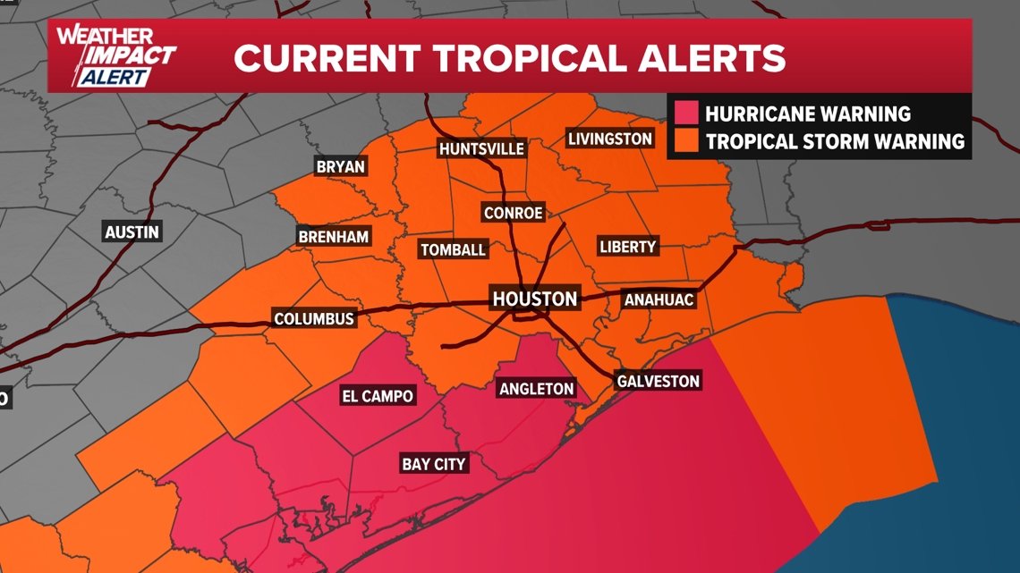
A Tornado Watch is in effect until 10 a.m. for Harris, Montgomery, Galveston, Fort Bend, Brazoria, Chambers, Liberty, and Matagorda counties.

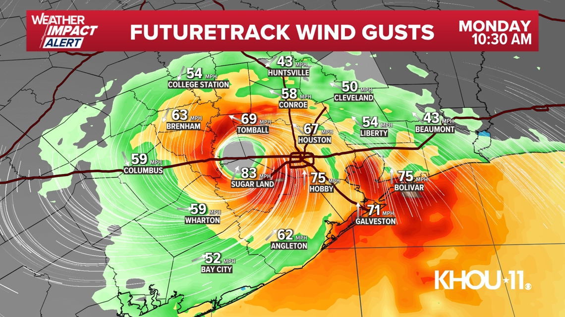
Although Beryl will weaken once over land, the storm will start to move quicker on Monday. As a result, substantial weakening is not expected until the storm passes through Houston on Monday afternoon. Tropical storm-force winds of up to 70 mph are possible in the City of Houston by midday Monday. Higher gusts, near 90 mph, are possible along the coast during landfall.

The good news is that conditions will rapidly improve Monday evening as Beryl races away from the area. Conditions will quickly dry out during the evening, and the sun will even break through the clouds for a large portion of the area. Tuesday looks much calmer, albeit hot, with sunshine returning and highs in the mid-90s.
Beryl 9 A.M. statistics
As of 9 a.m. on Monday, Beryl remains a Category 1 hurricane with maximum sustained winds of 75 mph, moving north-northwest at 12 mph.
Live tropical tracker
Beryl forecast cone

Be prepared
Disaster declaration


More than 120 Texas counties were placed under a disaster declaration, including Harris, Ft. Bend, Galveston, Brazoria, Montgomery and more. You can see the full list of counties here.
Evacuations
Officials called for voluntary evacuations in parts of Galveston, Matagorda and Brazoria counties.
Sunday afternoon, the Town of Quintana ordered a mandatory evacuation order.
Matagorda County evacuations are for those living on or visiting areas along the coast, including residents in Sargent, Matagorda and Palacios.
The Galveston County order went into effect at 10 a.m. Sunday for residents and visitors west of 103rd Street not protected by Galveston’s Seawall.
Brazoria County called for voluntary evacuation for all low-lying areas south of the Intracoastal Canal, including Bryan Beach, the Village of Quintana, the Village of Surfside Beach, Follett’s Island, and Treasure Island.
Record-setting Beryl