28 November 2024 marks ESA and Airbus review of EarthCARE’s commissioning phase, which validates whether all of the satellite’s systems are operational and performing well in orbit. Let’s focus on the inner workings of EarthCARE’s most advanced instrument, and the world’s only operational ultraviolet atmospheric LiDAR, Atlid, designed and built by Airbus. This instrument’s data is essential for scientists to better understand and monitor the role of aerosols and clouds in impacting climate change over the years.
You said LiDAR? But what is it?
LiDAR stands for Light Detection And Ranging. It’s relatively straightforward to explain how it works: it emits a laser pulse onto a surface and catches the light that bounces back – the echo – and the time it takes for the echo to return is used to measure the distance to the target. But applying this technology in space and to the scientific needs of the EarthCARE mission is another story, which led Airbus engineers to develop an atmospheric lidar that operates in ultraviolet light. Why ultraviolet light? Because it is the best wavelength to probe aerosols in the atmosphere.
Most optical instruments in space are passive, taking images of a scene illuminated by the Sun. Atlid is an ‘active’ instrument, meaning that the light source is the laser itself, which emits short pulses. These waves bounce off the atmosphere and clouds, creating echoes made of photons that are then recovered.
Better than microsecond precision
Analysing these faint echoes coming from tiny particles floating in the atmosphere requires extremely powerful transmitter and receiver systems capable of counting single photons. The numbers are mind-boggling. “The lidar emits a pulse of light and records the echo 51 times per second. Each echo is attenuated by a factor 1015, which means that we send 1 billion times 1 million photons to capture just a single one,“ explains Géraud de Villele, Airbus Atlid instrument System Manager. In the end, the Atlid lidar laser recovers only a few hundred in the receiving telescope.
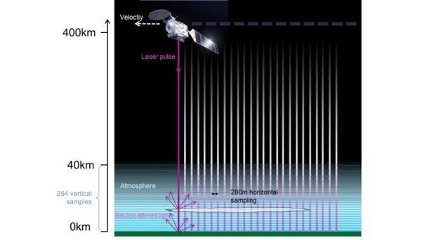
This delay between the moment when the wave is sent and its return is not of the order of minutes or seconds, but milliseconds. “Light travels the distance of 400 km to the atmosphere in a bit more than 1 millisecond, so we trigger the acquisition 3 milliseconds just after the laser emission pulse, and then we precisely record the atmospheric echo as if we were cutting the atmosphere in a giant vertical cake with slices 100-metres thick,” explains de Villele.
But Atlid’s capabilities don’t stop at vertical sampling of the atmosphere, it’s much more than that. This instrument also analyses the few photons that are backscattered from each slice of the air in the atmosphere. Operating in the UV range at 355 nm, it is equipped with a high spectral resolution filter that separates the Mie and the Rayleigh signals* and sorts the photons by their wavelength and polarisation. It makes it possible to precisely quantify – within this backscatter – the aerosols, droplets, or dust emitted by atmospheric pollution or by nature (sand, ash, etc).
Lidar laser light does not pass through thick clouds, but it can assess the transparency of wispy cirrus clouds and give information on the cloud tops. It also measures the height of clouds and how they move in the upper or lower atmosphere.
Atlid works together with another instrument, the Cloud Profiling Radar (CPR) that can penetrate deeper into clouds. The two instruments are able to probe the atmosphere giving a notion of depth, like sonar in the ocean. It’s a world first to have these two active instruments onboard EarthCARE, providing real time synergy of their measurements.

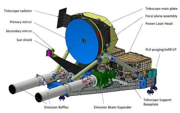
Atlid architecture. The long emission baffles at the end of the two laser heads minimise the risk of contamination of the optics.
Challenges for atmospheric lidar in space
Lidar technology is used for many applications on Earth, from recreating a 3D space like when an estate agent takes exact measurements of rooms inside a house, to measuring the height of forests. Such systems on Earth do not usually focus on the light echo properties but more on timing and don’t have to investigate a distant target 400km away.
The requirements for using lidar in space are much higher. As you have to analyse a signal from 400km away, you need extra high sensitivity of the detection system. Then the laser source must operate 24 hours a day, firing every 20 milliseconds, so over 4.3 million times per day – with no possibility of maintenance once in space.
With its continuous operation, the laser is dissipating high thermal power while needing high stability. “We designed and integrated a cooling system that extracts the heat emitted by the laser and channels it into a large radiator that exchanges the heat with the cold in space,” explains de Villele. “There has to be a certain amount of thermal stability inside, about 0.5 degrees, to avoid distortions related to thermoelastic problems.”
The additional challenge is to manage high dissipative sources nearby dozens of small optics that have to remain aligned for the whole mission within micrometres (a micron is one thousandth of a millimetre). In order not to lose any precious captured photons, the emission laser and the reception telescope are kept aligned using automatic co-alignment.
Learning from Aladin wind lidar
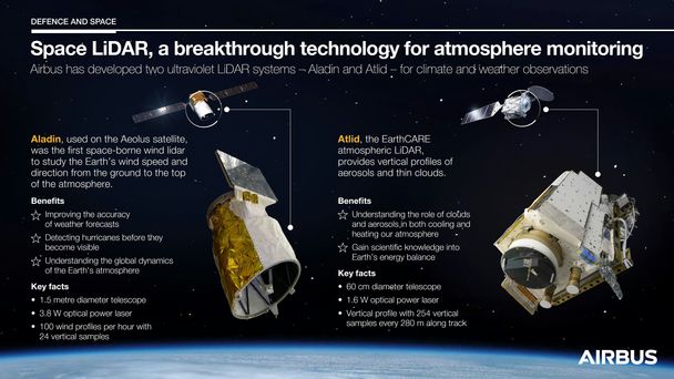
Compared to Aladin – the lidar used on ESA’s Aeolus wind-profiling satellite – Atlid is part of the second generation of lidar, but lessons have been learned from its older brother.

Unlike most instruments on satellites, where all units are exposed to a vacuum, the laser units of the Atlid instrument are in a pressurised atmosphere. “There are two reasons for this. The first one is to recreate the same atmospheric pressure as during ground tests. The second one is to avoid contamination effects that could blacken the high-power UV laser optics exposed to the vacuum,” says de Villele.
In addition, the optical system that receives the echoes is separate from the one that emits the laser pulses, and is therefore protected from the high power flux.
“Atlid and Aladin open the door to other space lidars. We’re beginning to master the technology,” says François Chassat, Airbus Atlid Project Manager. “Scientists are looking for even more precise tools that can combine wind and aerosol measurements, a clever mix of climate science requirements and more operational needs for weather forecasting.”
Atlid’s initial measurements are already providing an unprecedented assessment of the impact of clouds on the climate.
Discover more about Earth Observation at Airbus
*Mie and Rayleigh scattering
Rayleigh scattering refers to the scattering of light by air molecules, which occurs when light interacts with particles much smaller than its wavelength. Rayleigh scattering from air molecules is enhanced in blue and enables us to see the sky in blue. Mie scattering, on the other hand, occurs when light interacts with particles equal to or larger than the wavelength of light, such as aerosols and water droplets.


