Be prepared for some rain Friday morning, as passing showers are making for a wet start to the weekend.
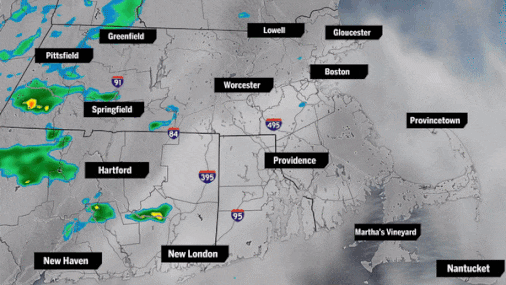
A stalled frontal boundary interacting with moist air has caused this unsettled weather. The rain will be concentrated in western New England as the front lingers in the area throughout the day and builds into scattered showers as the sun helps heat up the surface. The showers and a thunderstorm or two will remain broken and scattered, but may have some heavy downpours with them over western parts of Mass.
Showers will begin to pop up across western New England between noon and 3 p.m. and if the showers hold together, Boston could see rain between 4 p.m. and 7 p.m.
The good news for beachgoers is that most of the rain activity should stay west of the coast for much of the day and folks across the Cape, North and South shores should stay dry the longest — scattered showers may begin to infringe on the coast later in the afternoon. Otherwise, clouds will remain thick with the chance for some small periods of sunshine.
In Greater Boston, it will be hot and humid, with highs in the 80s.

Late Friday night will bring a slight chance of showers with isolated thunderstorms, some of which could produce heavy rainfall. It will be humid with lows in the 70s.

Saturday will be mostly cloudy with a chance of showers in the morning, then a chance of showers and thunderstorms in the afternoon. It will be another muggy day, with highs in the mid-80s — 70s to lower 80s on Cape Cod. There’s a low risk for a couple of storm cells to turn severe — but that should be more so across Western New England.
Ken Mahan can be reached at ken.mahan@globe.com. Follow him on Instagram @kenmahantheweatherman. Emily Sweeney can be reached at emily.sweeney@globe.com. Follow her @emilysweeney and on Instagram @emilysweeney22.