A widespread snowfall is in store for the Rockies that may have skiers happy but travelers concerned this week. A potent Pacific storm is upcoming for the Northwest at week’s end.
A semi-truck flipped over after sliding on an icy highway near Prince Albert, Saskatchewan, Canada, on Nov. 21.
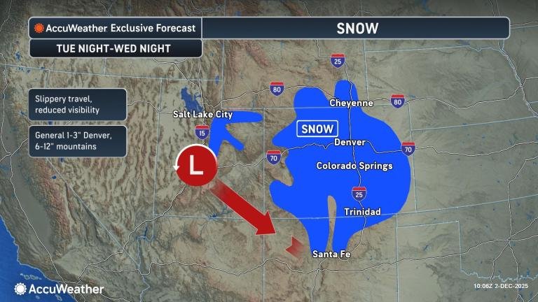
A storm producing snow over interior British Columbia at the start of the week is expected to move southeastward along the Rockies, causing snow to spread from Montana to Colorado, as well as across the northern tier of the Plains during the first half of the week.
Widespread heavy snow is not expected with this storm, but enough could fall to create slippery conditions and exacerbate travel headaches in areas beyond the Midwest and the Northeast. A broad area where 1-3 inches of snow is likely to fall is forecast over much of Montana, Wyoming and central and western Colorado, with locally higher amounts.
Denver’s forecast snow will fall in the 1- to 3-inch range, which would make it the biggest storm of the year so far. As of Monday, the city had only measured 0.2 of an inch of snow, compared to a historical average of 9.3 inches by Dec. 1. The snow in Denver is forecast to begin Tuesday night and continue into Wednesday afternoon. Airline passengers should anticipate delays due to slippery runways and deicing operations.
Dangerous travel along 500 miles of Interstate 25 is anticipated with the storm, as well as at least a couple of hundred miles of interstates 94, 90, 80 and 70 that perpendicularly intersect I-25 in the region.
Snow is forecast to fall on Salt Lake City from Tuesday night to early Wednesday, which has only experienced a few flakes so far this season. The typical snowfall through Dec. 1 is 7.5 inches. Meanwhile, the railroad and highway hub of Cheyenne, Wyoming, has fared a little better with snow, with 2.3 inches, compared to a historical average of 14.4 inches. The storm from Tuesday night to Wednesday night is forecast to bring a coating of an inch or two.
Snow is likely to extend farther south into southern Colorado and northern New Mexico. At least a couple of inches is forecast to fall on Colorado Springs. Several inches of snow are likely to blanket the Colorado Rockies and the mountains of northern New Mexico by the middle of the week.
The coldest air of the season so far, backed by a shift of the polar vortex, is likely to invade the north-central United States in the wake of the storm.
Even though the core of the Arctic plunge is expected to be directed east of the Rockies, it could lead to below-zero temperatures over the northern portion of the Plains at times, with AccuWeather RealFeel® Temperatures well below zero over stretches of many hours.
In the wake of the storm dropping southward over the Rockies, a period of gusty winds may rattle some areas in Southern California.
The plentiful rainfall in recent months could help keep the wildfire risk to a minimum. However, wind gusts can become strong enough in some open areas, through the canyons and over the passes to lead to sporadic power outages and raise the potential for high-profile vehicle rollovers.
“A storm forecast to enter the Northwest late this week may have a long connection to Pacific moisture, known as an atmospheric river,” AccuWeather Senior Meteorologist Brett Anderson said.
That storm is forecast to bring locally heavy low-elevation rain and mountain snow, as well as pockets of ice, in portions of Washington, Oregon, Idaho, Montana and British Columbia. The storm is likely to cause trouble for travel in the region from Thursday night to the start of the weekend. Interstates 5, 15, 82, 84 and 94 are likely to be affected, as well as Canada Highway 1. Along I-5, enough rain may fall to lead to flooding in poor drainage areas, including in Vancouver, Seattle and Portland, Oregon.
More stories of interest:
Want next-level safety, ad-free? Unlock advanced, hyperlocal severe weather alerts when you subscribe to Premium+ on the AccuWeather app. AccuWeather Alerts™ are prompted by our expert meteorologists who monitor and analyze dangerous weather risks 24/7 to keep you and your family safer.