California’s snowpack remains below average despite the powerful atmospheric river storms that pounded the West Coast around Christmas, state officials announced Tuesday.
The Department of Water Resources’ first snow survey of the season revealed that statewide snowpack is 71% of average for the date, compared with a 30-year baseline from 1990 to 2020. Last year, that number was 115% of average at the same time. Snowpack is a key component of California’s water supply, with the annual melt in the spring and summer feeding into rivers and reservoirs and helping to provide about about one-third of the water used for drinking, agriculture, nature and other needs.
“It’s still pretty early for the water year and our winter season,” said Angelique Fabbiani-Leon, a hydro-meteorologist with DWR’s snow surveys and water supply forecasting unit. “The conditions in the coming months, especially January all the way through the end of March, are really going to be telling.”
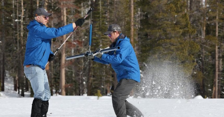
Fabbiani-Leon spoke from the state’s survey site at Phillips Station near South Lake Tahoe, where the snow depth was 24 inches with a snow water content of 5 inches — roughly half of average for the area.
However, she noted that just a week and a half ago, the survey site was bare ground — a marker of how quickly conditions can change in California. Last week’s series of atmospheric rivers broke rainfall records and went a long way toward improving the state’s snowpack conditions, but the next three months will be crucial.
“California’s snowpack is highly dependent on individual atmospheric rivers and winter storm systems,” Fabbiani-Leon said. “It is common for a handful of these storms to provide the bulk of the snowpack each season, and we have seen an example of this just in this past month.”
On Tuesday, statewide snowpack measured 24% of the average for April 1, the date when snowpack is typically at its deepest.
But not all areas of the state are blanketed equally. Snowpack in Northern California is trending below average at 51% of that April 1 benchmark, while Southern California is trending above average at 94%, a reversal of typical trends based on the storm patterns so far this year.
Climate change is also complicating the picture, not only by exacerbating “weather whiplash” — rapid swings between extreme wet and extreme dry conditions — but also because warmer average temperatures are making more precipitation fall as rain instead of snow.
“We’re off to a good start now, but keep in mind that a lot of good starts have come to a screeching halt,” said state climatologist Mike Anderson. He pointed to 2022, which started wet but then dwindled to a very low April 1 snowpack.
Still, state water managers breathed a sigh of relief about the marked improvement from the dry start to the month. Most of the major reservoirs are measuring above normal for the time of year, state data show.
“The trend that we’re looking at right now is more rain than snow,” said David Rizzardo, hydrology section manager with DWR. “We’d like to see the snow accumulation pick up by April 1 so we’re closer to average. It’s still to be determined in terms of how this year works out, but January, February and March are all big months in terms of snowpack accumulation, so we’ll keep optimistic.”
Andrew Schwartz, manager of UC Berkeley’s Central Sierra Snow Lab in Donner Pass, said warm early-season storms aren’t necessarily a bad thing because they help dampen the soil, but that “we really want to develop that seasonal snowpack so that we have that water going into spring and summer.”
The latest storm system transformed the area around the snow lab, Schwartz said, and he is now cautiously optimistic about the rest of the season.
“We’re not anywhere to be celebrating or panicked yet,” he said. “If we can balance out the central and northern Sierra and get some more snow up in these areas, then we could be looking quite good.”
Many skiers celebrated the state’s recent coat of powder. Officials at the Palisades Tahoe ski resort reported 65 inches of snow over the last week — referring to last week’s storm as a “Christmas miracle.”
Officials are hopeful that incoming New Year’s storms will keep improving the snowpack ahead of the next survey in early February. A weather system heading for the state is expected to drop up to 20 inches of snow across much of the Sierra Nevada in the coming days.
In the Los Angeles area, up to 3 inches of rain are expected in the basin and up to 5 inches in the foothills and mountains.
The precipitation is expected to start Wednesday night.
Meanwhile, the latest seasonal outlook for the first three months of 2026 from the National Oceanic and Atmospheric Administration calls for equal chances of wet or dry conditions in Northern California, and below-normal precipitation in Southern California.
“We’re all learning in real time the implications of all these unique kinds of water years that California is starting to experience,” said DWR director Karla Nemeth. “Our hope is always for a Goldilocks season — not too little and not too much — but we’ll have to see what the rest of this year brings.”