Last updated: Thursday, November 13, 2025 5:19AM GMT

Stream Southern California’s News Leader and Original Shows 24/7
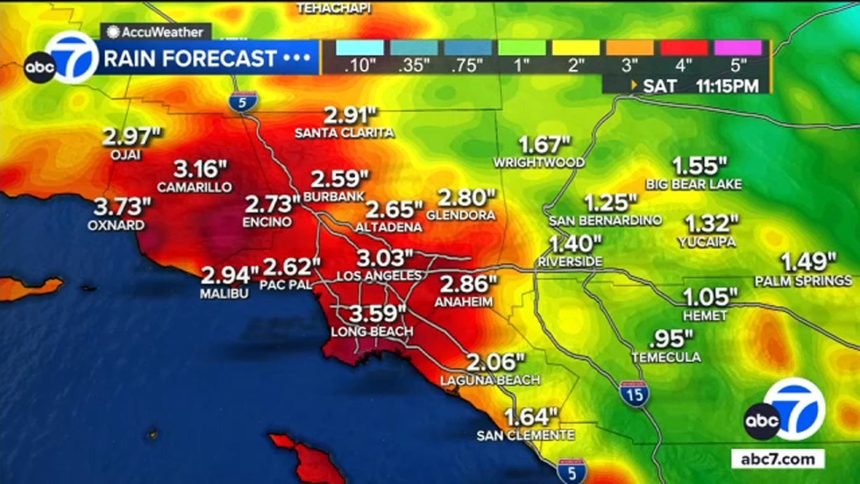
A storm set to arrive in Southern California on Thursday evening is threatening to bring heavy rain and possible mudslides to areas burned by wildfires.
Rain is expected to last through the weekend and possibly into next week.
Here’s everything you need to know about the storm system:
Key Headlines
Here’s how the news is developing.
3 hours and 28 minutes ago
LA’s emergency operations center to open Thursday at 6 p.m.
Los Angeles Mayor Karen Bass said the city’s Emergency Operations Center will be activated at 6 p.m. Thursday.
“The Mayor’s Office will continue coordinating with the Emergency Management Department, LAFD, LAPD, L.A. County Public Works and relevant City Departments to ensure all personnel are ready to respond as needed to keep Angelenos safe,” read a statement released on Wednesday.
Bass also said 13,000 feet of K-rail is still in place in Pacific Palisades to help with any possible debris flows.
Meantime, the Los Angeles Homeless Services Authority (LAHSA) has started conducting outreach to let unhoused individuals know about the storm and offer safety information and supplies.
Bass said hotel vouchers will be activated for those in need.
Topanga Canyon Boulevard to close Thursday night
Topanga Canyon Boulevard, or State Route 27, will close to the public at 10 p.m. Thursday, Caltrans said on X.
The road will be closed from the Pacific Coast Highway to Grand View Drive ahead of the storms expected Thursday night and into the weekend.
Evacuation warnings issued for LA County burn scar areas
Evacuation warnings have been issued for several burn scar areas in Los Angeles County as officials prepare for heavy rain and possible mudslides.
The warnings will go into effect on Thursday at 6 p.m. and will last through Sunday at 11 a.m.
The burn scar areas include Canyon, Bethany, Eaton, Palisades, Hurst, Kenneth, Sunset, Lidia, Franklin, and Bridge.
Weather forecast for SoCal beaches and mountains
The beaches and mountains in Southern California are expected to see rainy days and cooler temperatures due to the storm expected in the region.
Rain is expected to both areas Thursday evening and into Friday. The rain could also linger into next week. For mountain areas, snow is expected in higher elevation early next week.
Temperatures at beaches will see highs in the 60s and lows in the 50s.

Temperatures in the mountains will be highs in the 40s and lows in the 20s.