


420PM update in the comments.
….
2pm update in comments below.
……
Promising news! 🩵🤞 We will see plenty of rain, no doubt, but the worst of the flooding issues should stay to our southwest and into central Texas. (They need the rain!)
This week’s forecast (tropics info)
Monday 7am
From Space City Weather
It Is Increasingly Likely That The Heaviest Rainfall This Week Will Fall Southwest Of The Houston Region
Eric Berger · Monday, June 17, 2024 6:47 AM
In brief:
*Our pattern is changing this week with the arrival of tropical moisture.
*This will lead to heavy rainfall over the Houston area, especially on Tuesday and Wednesday.
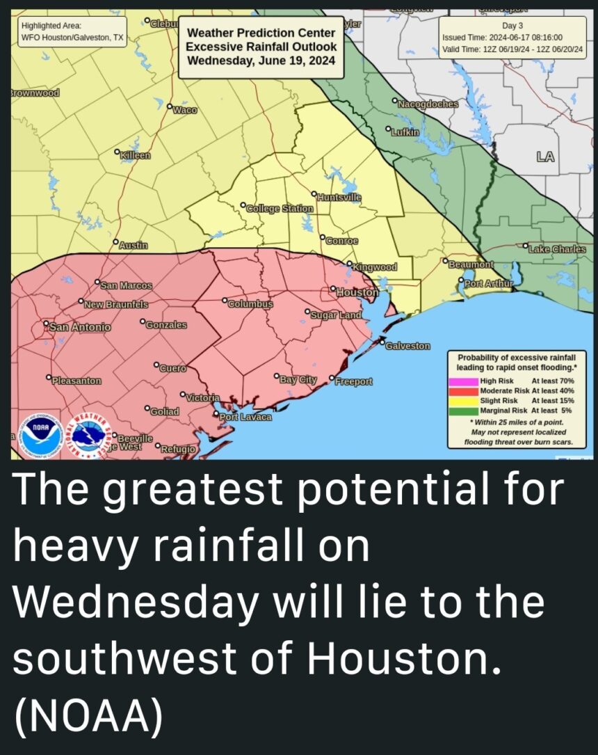
*However, our concerns for Houston are lower today with much of our model guidances now projecting the most extreme rainfall further south, near the Coastal Bend and areas such as Corpus Christi.
TROPICAL MOISTURE ARRIVING
*A surge of tropical moisture will move into Texas this week.
*However, based upon trends in the forecast over the last 24 hours, the threat of the heaviest rainfall has shifted south of the greater Houston region, including Galveston Island.
*This does not mean it is not going to rain in the Houston area this week.
*What it does mean that our risk of seeing extreme rainfall totals and widespread flooding is lower.
*For the time being we are going to maintain a Stage 2 flood alert for the Houston area through Wednesday given that the potential for high rainfall rates remain.
*Localized areas, especially near the coast, are still likely to see flooding.
*However, a Stage 2 event for Houston can now be considered a worst-case risk scenario.

MONDAY
*A large area of low pressure in the far southwestern Gulf of Mexico is starting to push a surge of moisture toward Texas this morning, and we’ve already seen some streamer showers.
*Atmospheric moisture levels will rise today, and as a result this afternoon I anticipate seeing fairly widespread showers and thunderstorms.
*A few areas could quickly pick up a couple of inches of rain, but totals for most locations should be less.
*Rain chances will slacken a bit tonight with partly to mostly cloudy skies, highs today will be in the upper 80s for most locations.
TUESDAY AND WEDNESDAY
*These days will see the highest threat for heavy rainfall, as tropical moisture levels peak in the atmosphere.
*As noted above, a majority of our modeling now indicates that the greatest potential for heavy rainfall-that is, the areas where we could see 12 inches or more of rainfall-are now south of Houston, in locations such as Matagorda Bay and Corpus Christi.
*That does not mean that Houston is out of the woods, so to speak. The environment is still favorable for heavy rainfall this week, it’s just a bit less favorable.
*In terms of expectations, much of the area along and north of Interstate 10 is likely to see between 1 and 5 inches of rain this week, with areas south of the freeway and closer to the coast likely to see 3 to 6 inches.
*The risk, for coastal areas, is that localized areas could see higher amounts. That remains possible given the state of the atmosphere. And high rainfall rates can quickly backup streets.
THURSDAY
*Rainfall remains possible on Thursday, even likely. But as moisture levels start to decrease, so too will the threat of heavy rainfall.
*Look for highs in the upper 80s with partly sunny skies.
FRIDAY, SATURDAY, AND SUNDAY
*We should see the return of partly to mostly sunny skies for the weekend, with highs in the upper 80s to lower 90s.
*However, as high pressure is unlikely to be in total control, each day may well have a decent chance of afternoon shower and thunderstorm activity with daytim


