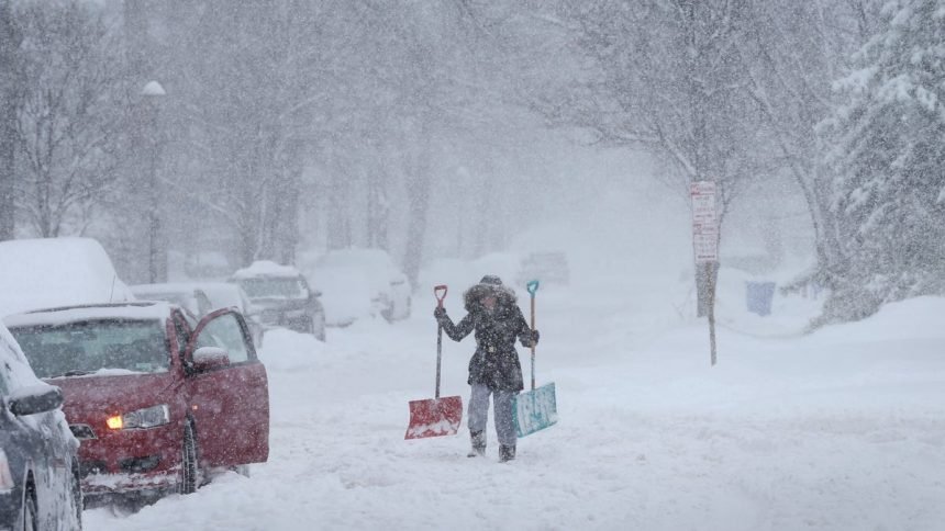
A powerful lake-effect winter storm combined with damaging winds will continue to impact much of western and central New York this week. Multiple winter storm warnings, wind warnings, and advisories are in effect, with hazardous conditions expected to last several days as lake-effect snow bands shift across the region.
This live blog will be updated as conditions change.
Winter Storm Warnings and Winter Weather Advisories remain in effect across much of western and central New York as lake-effect snow continues Wednesday, bringing hazardous travel conditions.
Several areas, including Genesee County, Wyoming, Chautauqua, Cattaraugus, southern Erie, Wayne, northern Cayuga, Madison, Oneida and Onondaga counties, could see anywhere from 5 inches to as much as 2 feet of additional snow through Thursday or Friday, depending on location. Periods of near-whiteout conditions, strong winds and snowfall rates of up to 2 inches per hour are possible, especially in lake-effect snow belts.
Additional advisories are in place for surrounding counties, where 1 to 6 inches of snow is expected. Forecasters warn that travel could be very difficult to dangerous during the morning and evening commutes and urge residents to avoid unnecessary travel and monitor forecasts.
New York State Electric & Gas (NYSEG) and Rochester Gas and Electric (RG&E) are continuing restoration efforts across Western and Central New York following widespread outages caused by Winter Storm Ezra.
The storm brought damaging wind gusts, lake-effect snow and ice, leaving more than 114,000 customers without power at its peak. As of Tuesday morning, more than 111,000 customers have been restored, with about 1,500 NYSEG customers and 1,700 RG&E customers still without service. The highest concentrations of remaining outages are in NYSEG’s Lancaster Division and RG&E’s Rochester Central Division.
NYSEG reported roughly 53,700 outages in its Lancaster Division, which includes parts of Cattaraugus, Chautauqua and Erie counties, with service restored to more than 53,000 customers. In RG&E’s Rochester Central Division, about 35,000 customers were affected, and more than 33,000 have since been restored. Most customers impacted earlier in the storm are expected to have power restored by midnight Tuesday, though additional outages remain possible as strong winds and lake-effect snow continue.
Both utilities say crews remain staged across the region and are working to restore service as safely and quickly as conditions allow. Customers are encouraged to monitor updates through utility websites, social media channels and mobile apps, and to report outages or downed power lines directly to NYSEG or RG&E.
Powerful winds swept across Western and Central New York on Monday as a winter storm moved through the region, with gusts exceeding 70 mph in several areas. The strongest wind was recorded at Buffalo Niagara International Airport, where a gust of 79 mph was reported late Monday morning. Other locations, including Fredonia, Dunkirk, Niagara Falls and Rochester, also saw gusts between 60 and 69 mph. The high winds contributed to power outages, downed trees and hazardous travel conditions across the region.
Governor Kathy Hochul expanded New York’s State of Emergency statewide as an intense winter storm continues to impact much of upstate New York.
After periods of ice and rain overnight, a long-duration lake-effect snow system moved into the state Monday morning. In Western New York, wind gusts reached up to 70 mph, creating dangerous whiteout conditions. Lake-effect snow is expected to persist off Lakes Erie and Ontario for much of the week.
While winds are forecast to weaken to 30 to 40 mph, whiteout conditions may still occur Tuesday in parts of Western and Central New York, particularly in the Syracuse metro area. Officials are urging residents in affected areas to avoid all unnecessary travel, follow local guidance, and telecommute when possible.
“As winter storms continue to impact several regions across Upstate New York, my message to New Yorkers remains the same: monitor local forecasts, avoid travel, and stay prepared,” Hochul said. “Plow crews, emergency management teams, and utility personnel continue to work to keep New Yorkers safe, and we stand ready to deploy additional resources wherever they are needed throughout the storm.”
Travel restrictions and vehicle bans are now in effect across parts of western New York as extreme winds create dangerous road conditions.
Orleans County Sheriff Christopher M. Bourke issued a travel advisory urging motorists to avoid unnecessary travel due to downed trees, fallen power lines, and hazardous driving conditions. Drivers are advised to use extreme caution if travel is unavoidable.
Road closures
- NY Route 5 (Skyway): Fully closed
Vehicle restrictions
A ban on tandem trailers and empty trucks and trailers is in place on the following roadways:
- I-90 (Thruway): Exit 46 (Rochester–Corning–I-390) to the Pennsylvania state line
- I-190: From I-90 to the Lewiston–Queenston Bridge
- I-290: From I-190 to I-90
- I-990: From I-290 to NY Route 263 (Millersport Highway)
- NY Route 400: From I-90 to NY Route 16
- U.S. Route 219: From I-90 to NY Route 39
- I-86: From the Pennsylvania state line to I-390
Officials say restrictions will remain in place until conditions improve and will provide updates as travel advisories and restrictions are lifted.
NYSEG and RG&E are actively responding to power outages across Western and Central New York caused by Winter Storm Ezra. The storm has brought strong winds, lake-effect snow, and icing, resulting in service interruptions across the region.
Approximately 14,000 customers are without power in NYSEG’s Lancaster division, which covers parts of Cattaraugus, Chautauqua, and Erie counties, while roughly 7,000 customers in RG&E’s Rochester Central service area in Monroe County are also affected.
The companies have more than 525 line and contract crews staged statewide to restore service. NYSEG and RG&E say crews are working safely and efficiently to repair outages as quickly as possible.
Customers are encouraged to monitor local updates and follow safety guidance while power is being restored.
The most severe conditions are forecast across several regions of New York, with snowfall totals measured in feet in some areas.
- Wyoming, Chautauqua, Cattaraugus, and southern Erie counties are under a Winter Storm Warning from 1 p.m. Monday through 1 a.m. Friday. Forecasters expect 1 to 3 feet of snow, with wind gusts up to 65 mph. Blowing and drifting snow could create frequent whiteout conditions, making travel treacherous and potentially life-threatening.
- Wayne and northern Cayuga counties are also under a Winter Storm Warning from 7 p.m. Monday through 7 p.m. Thursday. Snow totals could reach 1 to 3 feet, with wind gusts up to 55 mph. The heaviest snow is expected Monday night through Tuesday evening, with lake-effect snow lingering into midweek.
- A Winter Storm Warning is in effect for Madison, Northern Oneida, Onondaga, and Southern Oneida counties, including Utica, Boonville, Oneida, Syracuse, Rome, and Hamilton, from 7 p.m. Monday through 7 a.m. Wednesday. Snow totals of 1 to 2 feet are expected, with localized amounts up to 3 feet. Winds gusting up to 50 mph could cause widespread blowing snow and whiteout conditions, especially overnight Monday into Tuesday morning.
A High Wind Warning is in effect from 4 a.m. Monday through 1 a.m. Tuesday for Erie, Niagara, Orleans, Monroe, Genesee, Wyoming, and Chautauqua counties.
Southwest winds of 35 to 45 mph, with gusts as high as 75 mph, are expected, particularly along the Lake Erie shoreline and near downtown Buffalo. These winds could down trees and power lines, leading to widespread power outages and making travel extremely difficult, especially for high-profile vehicles.
Several Wind Advisories and Winter Weather Advisories remain in effect:
- Monroe County could see 4 to 8 inches of snow from Monday afternoon through early Tuesday, with wind gusts up to 60 mph impacting both the evening and morning commutes.
- Northern Erie and Genesee counties may receive 2 to 5 inches of snow through Monday evening, with blowing snow causing brief whiteout conditions.
- Steuben County is expected to see 3 to 7 inches of lake-effect snow through Wednesday, with gusty winds reducing visibility.
- Livingston, Ontario, Allegany, Wayne, and northern Cayuga counties are under wind advisories for gusts between 50 and 55 mph, which could down tree limbs and cause scattered power outages.
- Portions of central New York and northeast Pennsylvania are also under wind advisories through Tuesday, with gusts up to 50 mph.
Thousands are without power across upstate New York as strong winds sweep across the region. Outage numbers are changing rapidly as crews respond and conditions evolve.
Residents can monitor outages using the power outage tracker, which provides real-time updates by county and location. Numbers may change quickly as power is restored or new outages are reported.
- NYSEG: outagemap.nyseg.com | 800-572-1131
- National Grid: nationalgridus.com | 800-867-5222
- RG&E: outagemap.rge.com | 800-743-1701
- Report outages directly to your utility company.
- Stay warm safely using blankets and layered clothing; do not use stoves or grills indoors.
- Keep refrigerator and freezer doors closed as much as possible.
- Use flashlights instead of candles to reduce fire risk.
- Check on neighbors, especially older adults or those who may need assistance.
- Wyoming, Chautauqua, Cattaraugus, and southern Erie counties: 1 to 3 feet of snow from Monday afternoon through early Friday, with strong winds and whiteout conditions possible.
- Wayne and northern Cayuga counties: 1 to 3 feet of snow from Monday evening through Thursday evening, with the heaviest snow Monday night through Tuesday evening.
- Monroe County: 4 to 8 inches of snow from Monday afternoon through early Tuesday.
- Northern Erie and Genesee counties: 2 to 5 inches of snow through Monday evening.
- Steuben County: 3 to 7 inches of lake-effect snow through Wednesday.
- Madison, Northern Oneida, Onondaga, and Southern Oneida counties: 1 to 2 feet of snow from Monday evening through Wednesday morning, with localized totals up to 3 feet.
Forecasters warn that lake-effect snow bands may shift repeatedly throughout the week, meaning snowfall totals could be significantly higher in areas where bands persist. Strong winds may worsen travel conditions, increase the risk of power outages, and reduce visibility.
Residents are urged to monitor forecasts closely, secure loose outdoor items, and avoid unnecessary travel during periods of heavy snow and strong winds.