Wickedpedia
“A lot of cities have a nice, neat grid, or at least something close to it. In Boston, [we] really [do] not.”
Boston takes tremendous pride in its history.
Present day Massachusetts was one of the first colonies settled in the early 17th century, later becoming the sixth state in 1788. Mass. was a key battleground in the fight for independence from under British rule, home to important acts of resistance and patriotism leading up to and during the American Revolution.
And, while just about any Bay Stater you come in contact with will proudly talk about the state’s impact on American history, where we can really see evidence of how old the state is – specifically the capital city – are the streets downtown.
Boston is not known for being the easiest place to drive. According to a recent study conducted by WalletHub ranking the best and worst cities to drive in, Boston is ranked 94th for traffic and infrastructure, with an overall score of 86 (100 being the worst).
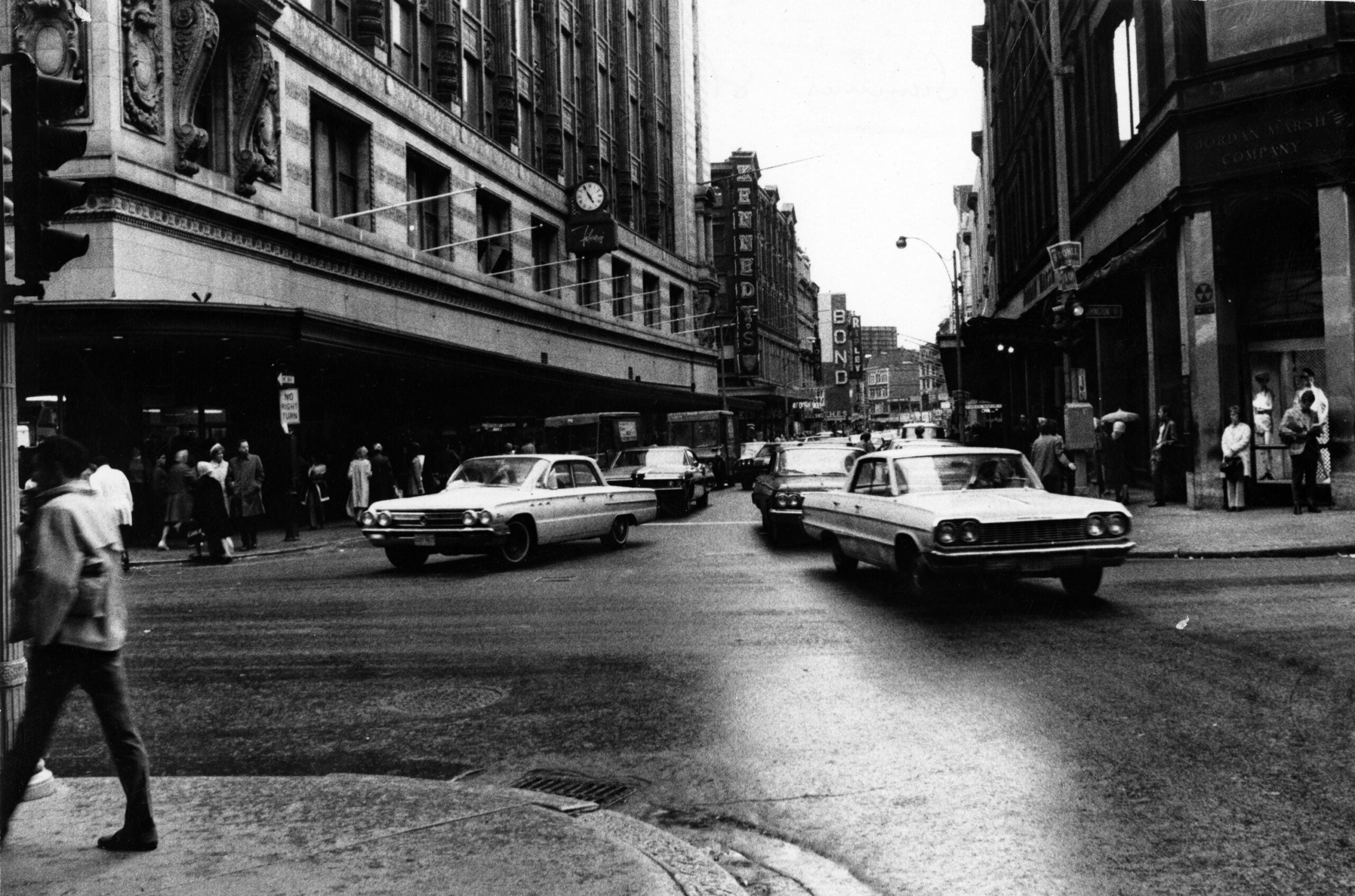
Bad traffic, one-way streets, and driving horror stories are not uncommon for major cities. However, what makes Boston especially unique is its topography – and lack of a grid system. But why is that?
For decades, people have said that it’s because of Boston’s agricultural roots, and came to the conclusion that the winding, confusing streets Downtown could only have one explanation: cows.
“I certainly heard it a lot growing up, and was even just talking about it with my family, and they were like, ‘What do you mean? That’s true,’” said Carina Ohlen, Education Manager at Revolutionary Spaces, the organization that stewards the Old State House and Old Meeting House museums.
Originally from New England, Ohlen also believed in this folk tale too until her time working as a historian.
“I think it’s just one of those things that gets passed down for a long time,” she said. “It’s something I was told when I was a kid, and I was probably telling people that until I started doing this.”
Some credit the myth to philosopher Ralph Waldo Emerson, Ohlen pointed out, who wrote in volume six of “The Works of Waldo Emerson (The Conduct of Life)” that “we say the cows laid out Boston. Well, there are worse surveyors. Every pedestrian in our pastures has frequent occasion to thank the cows for cutting the best past through the ticket and over the hill.”
Phlen says there’s some truth to it, but there’s a few different reasons why Boston’s streets look the way that they do.
While cow paths could have laid the foundation for the streets we know and loathe today, much more solid evidence is found in the way that Boston was settled.
“I think in some ways, you can’t totally discount the idea that maybe they were formed by cows a little bit because cows were living in that space,” Ohlen said. “Back then [in] that whole Downtown area, there was a lot more agriculture. It’s really built up now, but I don’t think I [can] say with 100% certainty that cow[s] didn’t make some of those streets.”
How were Boston streets designed?
Founded in 1630 by English settler and Anglican Priest Reverend William Blackstone, The Shawmut Peninsula – now modern day Boston – was primarily marshland. Originally inhabited by the Massachusett and Wampanoag people for thousands of years, those indigenous to the land made a home here, and some traveled to Shawmut seasonally for fishing.
“People had been moving throughout this space for quite some time,” Ohlen added when talking about the history of settlement in Boston. “Boston is primarily marshland, and was a lot smaller when it was founded. Things [were built] around all the natural features.
For the past century, existing evidence of Indigenous fishing practices have been uncovered. In 1913, fishweir fragments were first found buried in the ground during the construction of the Green Line down Boylston Street, which archeological evidence suggests is from 3,600 to 5,200 years ago.
The city of Boston as we know it began forming around the Great Spring, a natural fresh water feature that was a suitable location to form a town.
“William Blackstone knew about [the spring and] let other people know about it. It’s kind of what made it possible for a lot of people to settle in Boston permanently,” said Ohlen.
“Because there was this flowing fresh water before they had built reservoirs and aqueducts, they used this as a fresh water system, and it really shaped the natural features of that Downtown area, because people were, of course, building around that really important water feature.”
Downtown Boston is a reminder of this living history. Walk around and look at the street names – it may be a signifier of what was originally there. The European settlers named the streets in a “practical” manner, Ohlen also pointed out.
“Spring Lane is the location of what would have been the Great Spring,” Olsen said. “It was flowing natural water, really important for European settlers coming to Boston because this was fresh water which was not present everywhere.”
What do Boston streets look like?
For those of us who regularly drive and walk throughout the city, we are accustomed to the one-way, narrow streets that feel winding and confusing until you know your way around. But what do the streets actually look like?
In comparison to other major cities in the U.S., our streets look very complicated.
“A lot of cities have a nice, neat grid, or at least something close to it. In Boston, [we] really [do] not; it’s very organic looking when you see it from a map,” said cartographer Andy Woodruff.
“It’s challenging to navigate on foot or in a car, even. It looks like a tangled mess at first glance, [but] I think I’ve looked at maps long enough of Boston that it starts to make sense to me a little bit,” he added.
Visitors are also able to pick up on these differences too. When asked if questions about Boston’s streets arise on city tours, Ohlen answered with an “absolutely.”
“Especially if people are very brave and decide to rent a car when they come to visit, they’re usually a bit shocked at the experience, and I always feel so bad,” Ohlen said. “It’s [even] stressful for people who have driven there their whole lives.”
So, how do Boston’s streets actually compare to other cities? Most commonly, that conversation includes references to New York City, Chicago, and Philadelphia.
“Philadelphia, for example, I think is almost as old as Boston, but it’s a lot more organized and less difficult,” said Woodruff. “I can’t really think of any large city, in the U.S., that is as difficult to figure out on the ground as Boston is.”
“I think people enjoy it though because it feels very old, maybe more European than what a lot of other cities are set up like. I think people find it interesting,” Ohlen said. “We definitely do get people asking about it, though, or comparing it to like New York or Chicago. I think those rivalries exist outside of the street design.”
How does Downtown compare to the rest of Boston?
When retracing the steps of Boston’s street formation, key points such as the Old State House and Old South Meeting House also help make sense of Downtown’s formation.
“In Downtown, it seems to me like the streets kind of all flow together towards several kinds of nodes. The Old State House is one of them,” Woodruff points out. “A lot of the streets south of there kind of converge and are connected in between by kind of confusing things. And I think this is [also] beyond Downtown, but I think a lot of Boston starts making sense to me if I think of these nodes and then streets and neighborhoods [as] kind of organized around those.”
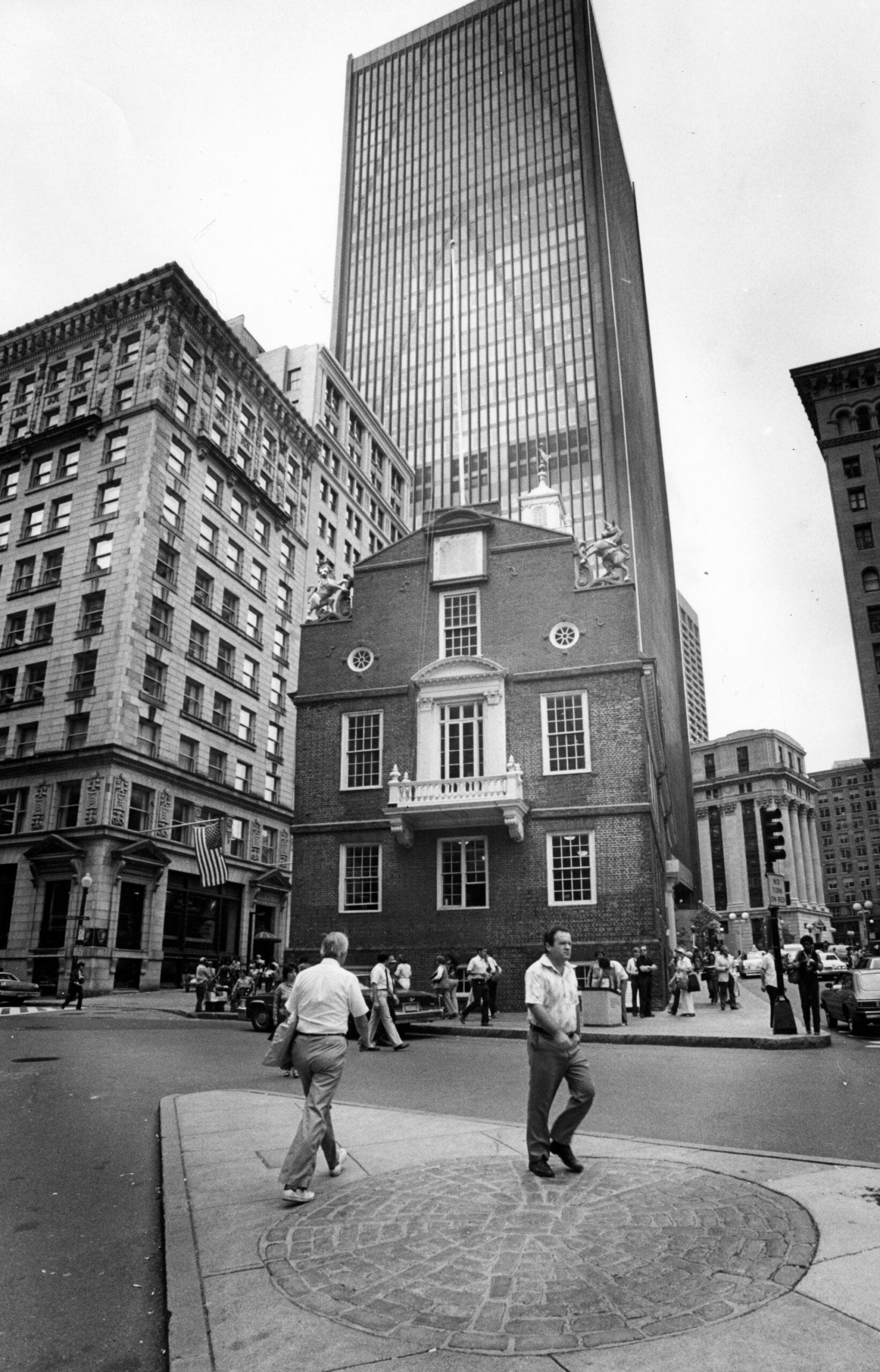
Evidence of this center has endured for the past four centuries. And instead of being passed by English settlers daily, it is now a hub filled with corporate buildings, major food and shopping chains, and tourist attractions.
“[With] the Old State House being sort of the center of the town at that time, a lot of things were built around it. You can even see that now [with] the way that it’s sort of positioned in the middle of Downtown with all these giant skyscrapers around it,” Ohlen said.
“Being the center of what was the town at the time, and being a keystone point for measuring the rest of the Commonwealth or colony at the time is really interesting.”
Although Boston’s streets have their own reputation, it’s not unique to just Downtown.
“You know about the streets [Downtown], not that they get much better outside of Downtown Boston, but they’re really crazy Downtown,” she added.
How to experience historic Boston streets
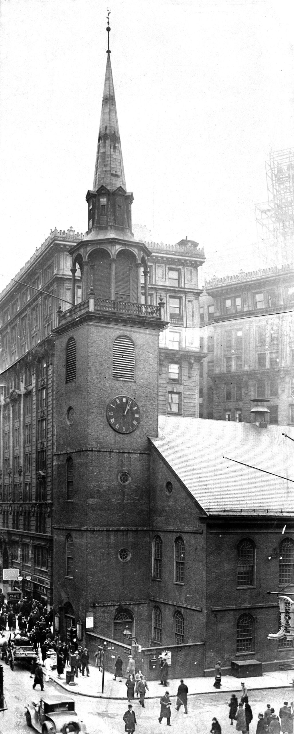
At the Old South Meeting House, visitors can take a look at a diorama map of the streets that is over a century old.
“You don’t get to see too much of [these maps] anymore,” Ohlen said. “It was based off of a book about the winding roads of Boston.”
Other places Ohlen recommends stopping by is the Gibson House Museum in Beacon Hill, a “time capsule” of all-things domestic life from the mid-19th to early 20th centuries, according to their website.
“They’re the experts to me on the history of Beacon Hill and the way that the city was sort of built up in the 19th century,” she said about the museum.
One of the most picturesque locations to explore in the neighborhood is on Acorn Street, which has maintained its colonial charm since the 1700s. With its original narrow width and cobblestone path, Acorn Street is a testament to the uniqueness and beauty of Boston’s historic streets.
Your next read could even be “The Crooked and Narrow Streets of the Town of Boston 1630 to 1822” by Annie Haven Thwing and published in 1920.
“It is something that people continue to research, because there’s so many things to uncover. I think you hear about changing history a lot, but it’s not that. We’re constantly finding new information and reevaluating the way that we look at history because of it,” Ohlen said.

Boston.com Today
Sign up to receive the latest headlines in your inbox each morning.