You might be headed for a destination on 17th Avenue, put an address into your phone app and then discover you mixed up that road with 17th Street.
Likewise, you might wonder: Why do some addresses have no directional letter — no “N” or “E” after the number?
Why are the streets diagonal in downtown Denver? And what drove how Denver streets are named?
Answers to these questions and more come from local historian Phil Goodstein’s book, “Denver Streets: Names, Numbers, Locations, Logic.” What’s more, the book sheds light on how the broader metro area was unified — mostly — under one street grid.
“Compared to cities such as San Francisco, Boston, Seattle, and New York, Denver roadways are a model of clarity,” Goodstein’s book says.
An understanding of the system and “the evolution of Denver streets not only reflects much of the city’s past, but is also literally a way where an individual can find where (they are) going,” Goodstein’s book adds.
Here’s a small guide to making sense of the map, mostly based on information from the book and some input from Goodstein himself, not necessarily listed in historical order.
Basics of the metro Denver grid
Whether you’re on a certain part of a road — West or East Alameda Avenue, or North or South Wadsworth Boulevard, for example — depends on which side of the map’s dividing lines you’re on.
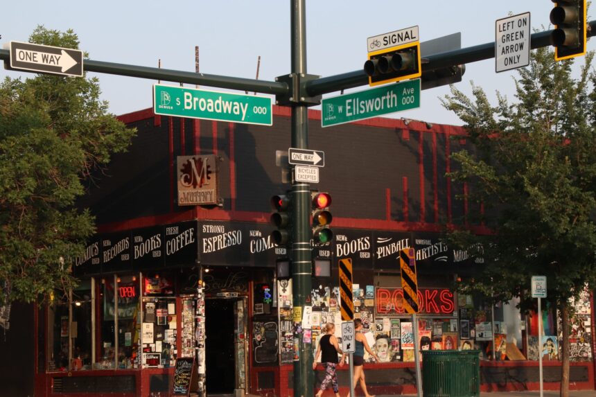
You can think about the Denver metro area as a grid with four quadrants. Broadway is the dividing line for avenues running east and west, so if you’re on West Colfax Avenue, that means you’re west of Broadway.
Likewise, the lesser-known Ellsworth Avenue, while not a major road on its own, is the dividing line for streets running north and south. To help you picture its location: Ellsworth sits next to 1st Avenue.
Those two axis lines, Broadway and Ellsworth, generally determine the number in addresses based on how far away a place is from those roads. And the metro area’s numbered avenues — 1st Avenue, 120th Avenue and so on — easily tell you how far a place is from Ellsworth.
Each full block on the map counts up by 100 in the address numbering system. For example, 1300 Broadway means a building is on Broadway at 13th Avenue.
If you stand at the Broadway and Ellsworth intersection, you can see each street sign display a “000” number, indicating it’s at the grid system’s center.
Avenues south of Ellsworth in Denver’s grid generally don’t include the handy numbers like “6th” in their names, but the system still applies, with each road carrying a number. Tennessee Avenue, 10 blocks south of Ellsworth, is the road marking 1000 south.
Technically, when writing addresses, the “N” for north and “E” for east are sometimes ignored. A street not having “South” in its prefix is assumed to be north of Ellsworth, and an avenue not having “West” in its prefix is assumed to be east of Broadway.
But “modern Denver practice has generally been to add prefixes to the east as well as to the west avenues,” Goodstein’s book says.
(When putting an address in an internet map system, pay attention to whether the directional prefix is correct.)
A quick note if you’re confused: West Colfax doesn’t mean you’re going westbound on Colfax. You can head east or west on that road. It just means you’re on the portion of that road that’s west of Broadway.
A crooked grid
But if there’s a simple north-south, east-west grid, why are there diagonal streets in downtown Denver?
The history goes back to the Auraria community, the place that now houses the campus that includes the Metropolitan State University of Denver off Colfax Avenue and Interstate 25. Auraria’s streets parallelled the Cherry Creek, and the nearby early Denver streets were laid out parallel to the Platte River.
The result is today’s somewhat messy diagonal grid system in the downtown area with its own separate numbering system from the rest of the surrounding area. Driving to 11th Street in the downtown-area grid — as opposed to 11th Avenue outside of it — will land you in very different locations.
‘Streets’ and ‘avenues’
You may notice that in the metro area, “streets” generally run north and south and “avenues” east and west.
“Originally, ‘street’ and ‘avenue’ had no specific meaning in the Mile High City,” Goodstein’s book says. “They were products of local custom and what developers, real estate agents, and residents named the roads in their areas.”
Eventually, “street” and “avenue” were given precise definitions that indicated which way they ran.
(There are some exceptions to that rule outside of Denver — more on that later.)
Despite that tidy order, in the downtown-area grid, generally, everything’s a “street.” And that diagonal grid is based on old Denver boundaries.
The original southwest corner of Denver at Colfax Avenue and Zuni Street near the Platte River was defined as “ground zero” for that grid in 1873. First Street was the first street northeast of Colfax and the Platte. 16th Street downtown is the 16th street from that point.
If a system with two grids is confusing, it’s helpful that something links them. The numbering system of the diagonal streets eventually also determined the numbers of the east-west avenues in the regular grid. 16th Street and 16th Avenue hit Broadway at the same place, as do 17th Street and 17th Avenue, which connect at that point.
“This is not coincidence, but a product of efforts to rationalize Denver street names and numbering,” Goodstein’s book says.
What that means is that a road in the regular grid wasn’t arbitrarily chosen as 1st Avenue. Rather, 1st Avenue was determined because the east-west numbered avenues started with 17th Avenue and counted down block by block until a first avenue was reached, Goodstein’s book says.

That brings things back to Ellsworth. The road one block south of 1st Avenue, Ellsworth, was consequently defined as the dividing line between the north-designated and the south-designated streets.
Straightening out
What locals today know as the regular east-west, north-south grid became dominant long ago.
Real-estate businessman Henry C. Brown pushed for a street system that naturally followed the compass, laying out the streets of the future Capitol Hill neighborhood on an east-west, north-south basis.
“Such a grid followed federal land policies and was seen as the most efficient means of profitably developing real estate,” Goodstein’s book says.
Setting order
With the coming of the railroad in 1870, Denver’s population spiked, and as it did, new sections emerged around the area.
“Only the barest of a building code and municipal supervision regulated new developments,” and a “chaotic street pattern” arose, Goodstein’s book says.
“By the 1890s, it was estimated that there were 832 names for 414 designated roads,” the book adds. “Often the same name referred to more than one street.”
It caused confusion. The problem “especially irritated Howard Maloney, a bookkeeper for the water company,” Goodstein’s book says.
“Maloney suffered much of the criticism when (people) complained about being double-billed or not getting service as ordered and promised. Messengers for the water company often could not find customers to deliver bills,” Goodstein’s book adds.
Maloney set out toward a solution. With the support of the water company, the city passed Ordinance 16 of 1897, paving the way for placing an alphabetical order on streets.
Maloney provided many of the street names in the new system.
Though street names don’t always follow an alphabetical pattern, one of the places the Maloney system comes into play is in streets east of Colorado Boulevard, in a “double alphabet” pattern. Here, for example, the name of the first street in the series, such as Clermont or Dexter, was a personal name or a geographic location, “ideally of British origins,” the book says. The next street, such as Cherry or Dahlia, was a plant or a tree. That continued east to Yosemite Street.
Denver’s initially chaotic street pattern wasn’t an anomaly compared to other major U.S. metro areas, Goodstein told Colorado Community Media.
“It was typical of cities everyplace at that period,” Goodstein said, speaking generally. “Every developer in every community would seize the land and try to develop it as they wish.”
Beyond Denver, in the suburbs
At the same time efforts were underway to define avenues with Ellsworth as the “zero” road, Broadway, which partly ends the downtown-area diagonal grid, logically emerged as the axis dividing east and west.
“Broadway is a generic term for a big important street by the time Denver has emerged,” Goodstein said.
By the 1890s, a vague idea of metro Denver had arisen. Arapahoe County collaborated with Jefferson County to try to rationalize the street system of the entire area based on Broadway and Ellsworth as the zero axes. (Long ago, Denver was part of Arapahoe County.)
Englewood, Sheridan, Aurora, Edgewater, and parts of unincorporated Jefferson and Arapahoe counties changed the names of their streets in 1906, Goodstein’s book says.
“The 4800 east block east, in other words, would always be Dahlia Street whether it is in the City and County of Denver or in one of the suburbs,” Goodstein’s book says of the grid system.
Separately, Littleton developed its own numbering system based on Main and Prince streets as its zero lines.
“In December 1960, over a good deal of local opposition, Littleton joined the Denver street numbering system and renamed many of its streets, effective 1961,” Goodstein’s book says.
Suburban streets often seemingly follow no specific pattern, but they are still generally part of the Denver numbering grid.
North metro residents may know that although it is the east-west dividing line, Broadway often disappears north of downtown Denver.
“Given that Broadway had originally ended at 20th Avenue, it never became a dominating arterial in the northern suburbs,” the book says. (“Arterial,” as in artery, means a major road.) “Especially north of 88th Avenue, I-25 follows what would have been the path of Broadway.”
Suburban quirks
In Boulder, Golden and Brighton — old, historic cities — roads exist outside of the greater Denver-area grid, even though Golden and Brighton generally fall within the Denver metro area.
In parts of Golden, “streets” run in both directions of the grid, and in parts of Brighton, “streets” run east and west, and “avenues” run north and south.
Castle Rock, far outside Denver but still technically in the metro area, also has its own street grid.
Some major diagonal roads in the Denver area are named for the communities they lead to. Brighton Boulevard goes toward Brighton, Parker Road toward Parker. While less cohesive, Morrison Road goes toward the Town of Morrison. It originally began at Colfax Avenue, the book says, where a tiny section of what is dubbed Morrison Road still runs near Federal Boulevard.

“Much of the original Morrison Road, the old county road 8, was filled in by subsequent urban development,” the book says.
In Denver and beyond, official logos on street signs reflect which city or county you’re in. See CCM’s previous story on street signs and some history at tinyurl.com/DenverMetroStreetSigns.
Other map features
Between the full blocks of the Denver street grid are “half blocks,” with roads that do not cut completely through the grid.
These small roads include “courts,” “places” and “ways.”
On the other hand, “boulevards” and “roads” are generally major roadways.
For more on history of Denver streets, see Goodstein’s book at the Denver Central Library.