Keep the umbrellas handy. The unsettled weather pattern that kicked off the week is sticking around.
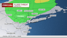
Expect showers and a chance of thunderstorms throughout the day Wednesday. Some of the storms may produce isolated, flooding downpours, but the threat is not considered widespread.
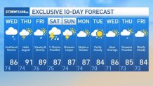
Highs temperatures will be in the 80s but feeling like the low 90s.
Under a heat advisory for Wednesday: New York City, Nassau, Essex, eastern Passaic, Union, Hudson, Bergen counties.
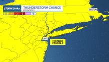
Some of Wednesday’s storms may produce isolated, flooding downpours.
Temperatures will spike after Wednesday. A front will scour out some of our humidity, but that also allows for higher daytime temperatures beginning Thursday.
High temperatures will hit 90 degrees with modest heat index levels approaching the mid-90s. We should stay below heat advisory criteria, but there will be no mistaking what season we’re in. Come Friday, it’ll feel like 100 again, thanks to the humidity.

In addition to higher heat, Thursday brings another chance for showers and storms. Rain will be possible at any time of day, including the morning and evening commutes.
Watch for ponding on roads in pockets of heavy rain and budget a little extra time getting to your destination.

Summer heat, humidity and scattered storms will continue Friday into Saturday. The high temperatures peak Friday, with the heat index near 100 degrees. Sunday is trending drier, but even then a stray shower or two cannot be ruled out.
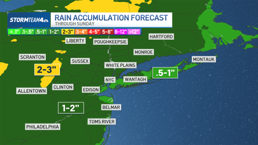
Factoring in multiple days with periodic rain, total accumulation will be anywhere from a half inch to 2 inches or more in isolated spots. Coastal areas will probably get the least rain, which is good news for beach-goers.

Check out your 10-day NYC forecast outlook below.
Track any approaching rain using our interactive radar below.