DENVER — We’re tracking another day of high fire danger Wednesday, something we’ve seen far too often this winter and early spring season.
Ahead of the strong winds, look for a relatively calm night with partly cloudy skies across the Front Range. Overnight lows will stay mild in the upper 40s to low 50s.
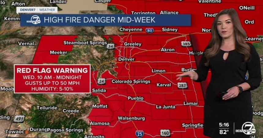
The winds will pick up Wednesday ahead of our next cold front. A Red Flag Warning is in effect for the entire Front Range and Eastern Plains from 10 a.m. to midnight Wednesday. Winds will gust up to 50 mph with humidity values between 5 and 10 percent along with unprecedented spring heat.
Wednesday’s highs will soar into the low to mid 80s in the Denver metro area with low 90s along the Eastern Plains. This means temperatures will be about 20 to 25 degrees above normal and just a few degrees shy of Denver’s record high of 89 degrees set in 2022!
Our next cold front will roll through on Thursday dropping highs back into the low to mid 60s. Even with the cooler weather, the winds will continue to kick up leading to another day of high fire danger for much of the state. In fact, a Fire Weather Watch is in effect for the Denver metro and plains Thursday.
Meanwhile, cooler and more unsettled weather moves into the High Country bringing a chance of light snow starting Thursday. It doesn’t look like a major storm, but rather off-and-on showers through the weekend, which would be a welcome change after such a warm and dry stretch. Denver will see a few scattered showers Saturday with a better chance of rain and possibly thunderstorms on Sunday.
Strong winds, sizzling temps lead to high fire danger in Denver metro, plains Wednesday
DENVER WEATHER LINKS: Hourly forecast | Radars | Traffic | Weather Page | 24/7 Weather Stream
Click here to watch the Denver7 live weather stream.