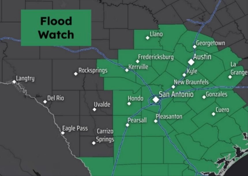
The highlighted counties in South and Central Texas are under a flood watch on Saturday, as isolated rainfall totals of 4 inches will be possible.
It’s been quite the stormy May in San Antonio. Not including Saturday rainfall, San Antonio has recorded 4.06 inches of rain this month, on track to be well above the climate-normal. The South Side has been even more active, with Stinson Municipal Airport measuring 6.36 inches of rainfall this month.
Another round of heavy rainfall is possible heading into Saturday. A flood watch is in effect across much of South-Central Texas, including San Antonio, Austin, and the Hill Country. However, this will not be an all-day rain event, as we will likely see extended breaks without rainfall. Here’s a look at when thunderstorms are most likely to develop.
Article continues below this ad
Saturday’s forecast
Through the early morning hours, rain chances in San Antonio will actually be on the low side, with just a 30% chance of showers and storms through 8 a.m. Temperatures will sit in the low 70s with cloudy and humid weather also expected.
By 8:30 to 9 a.m., chances of thunderstorms will start to increase across the region, as a potential cluster of storms moves in from the west. Overall rain chances will be around 60% between 8 a.m. and noon.
A lull in the precipitation is expected by the middle of the day. But by the late afternoon and evening, a few scattered thunderstorms will be possible once again. San Antonio storm chances will rise back to around 40% between 4 and 8 p.m. Afternoon storms will occur sporadically around the area, making it difficult to pinpoint the exact time that they’ll move into San Antonio.
Article continues below this ad
How much rain? Recent model data has trended downward for potential rainfall totals across the region. Most areas will likely see less than 2 inches of rain, with the National Blend of Models now projecting between a half-inch and 1.5 inches of rain for San Antonio.

Shown are the “most likely” rainfall totals projected for this weekend, according to the National Weather Service. Isolated higher amounts will be possible.
By itself, an inch of rain would not result in flash flooding. However, this particular weather system will likely produce a few slow-moving thunderstorms with high rainfall rates, resulting in isolated rainfall totals of up to 4 inches in or near San Antonio. That is why the flood watch is still in place.
Article continues below this ad
In addition to potentially heavy rain, a few thunderstorms also might be capable of quarter-size hail and damaging wind gusts of up to 60 mph. However, most of the activity will stay under these severe weather thresholds.
Sunday and Monday forecast
As a low pressure system over Texas starts to move east, rain chances across South-Central Texas will start to decrease. Still, about a 30% chance of scattered showers and thunderstorms is anticipated Sunday afternoon and evening, some of which could produce heavy rainfall.
By Monday, storm chances will be even lower, which is great news if you plan on grilling out for Memorial Day. Rain chances in San Antonio will be at just 20%.
Article continues below this ad

Shown are the expected high temperatures across South Texas on Memorial Day.
As rain chances fall and sunshine increases, temperatures across South Texas will start to rise a few degrees. Highs are likely to be in the mid- to upper 80s in San Antonio through Monday afternoon, and continued high humidity will push “feels like” temps into the low 90s.
Another round of storms
Another significant chance of showers and thunderstorms is expected by late Tuesday afternoon and heading into early Wednesday. Because the ground is already likely to be saturated, more heavy rainfall will not be able to soak into the ground, creating more runoff and worries about flooding.
Article continues below this ad
Tuesday evening rain chances are expected to rise to around 60% in San Antonio. After that, the region will still have a 50% chance of rain Wednesday, followed by a 30% chance of more storms on Thursday.